
Parish Church of the Holy Trinity on Gray

.jpg)
.JPG)
The parish and pilgrimage church of the Holy Trinity on Gray is under the patronage of the Holy Trinity. It is located at an altitude of 1180 meters under the wooded hill of the Sonntagsberg in the community of Frauenstein .
History and structure
According to legend, a small wooden church was built at the place where the Holy Trinity appeared to a pious farmer from Obermühlbach, and later also to the pastor.
The church, first mentioned in 1724, was elevated to a parish church in 1785. The sacred building is the rare example of a log church in Austria . The brick choir and the brick sacristy attached to the north were built in 1785. The long house, a log building with a shallow barrel, is probably older. The wooden roof turret dates from 1865, the western porch has been renewed. The western half of the nave is taken up by a wooden gallery on four supports, the eastern half was boarded around 1860.
Facility
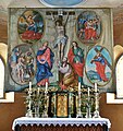
The altar leaf of the high altar, which was built around 1720, with its carved leaf and ribbon frame shows a mercy seat . The right, neo-baroque side altar was created in 1905 by Mathias Slama.
On the basket of the pulpit from around 1700, between the statuettes of the evangelists (replicas after the stolen originals), the painted representations of the apostles Phillipus , Jakobus major, Andreas and Bartholomäus can be seen.
Four console statues in the choir, carved around 1740, depict the saints Christophorus , Stephanus , Barbara and Donatus and are attributed to Johann Pacher .
The church owns a central-type fasting cloth from around 1800 with the crucifixion scene in the middle and four passion scenes in medallions ( Gethsemane , flagellation, crowning of thorns, carrying the cross).

Side altar

Baroque pulpit of the Trinity Parish Church on Gray

Signature of the painter

St. Christophorus, console statue in the choir room
Lent cloth, created around 1800
.jpg)
.jpg)
.jpg)
.jpg)
.jpg)
literature
- Dehio manual. The art monuments of Austria. Carinthia . Anton Schroll, Vienna 2001, ISBN 3-7031-0712-X , p. 862.
Web links
Coordinates: 46 ° 48 ′ 22.8 ″ N , 14 ° 17 ′ 5.5 ″ E