
Pics de Sindou

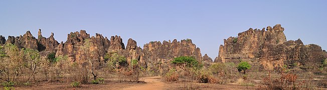
The Pics de Sindou or Aiguilles de Sindou are a group of steep-walled and heavily eroded sandstone cliffs in southwest Burkina Faso . Its highest point reaches 415 m. ü. M.
The rock group is located near Sindou and about 40 kilometers west of the city of Banfora in the Léraba province . In the Senoufo traditions they are considered a place of protection from danger and a place of their mysticism. They are also one of the most popular tourist attractions in the country. The diversity of habitats in their area makes them important for the biological diversity of the region.

Pics de Sindou in the background
View of the Pics de Sindou from the street

Tower and cathedral structures in the Pics de Sindou


Web links
- Georges Hugot: à la Recherche du Gondwana perdu . Université Montpellier III , Montpellier 2002 on www.mgm.fr (French, PDF)
Individual evidence
- ↑ Jean Marie Dipama: Principaux facteurs environne-mentaux du Burkina Faso . PDF document p. 127 (map: Unités géologiques du Burkina Faso) online at www.goethe-university-frankfurt.de (French, English)
- ↑ Anonymous: Pics de Sindou 'au Burkina Faso . on www.burkina-faso.ca (French)
Coordinates: 10 ° 39 ′ 25 ″ N , 5 ° 9 ′ 9 ″ W.