Leraba
| Basic data | |
|---|---|
| Region : | Cascades |
| Capital : | Sindou |
| Departments : | 8th |
| High Commissioner : | |
| Area : | 3132 km² |
| Residents : | 152,034 (2013 estimate) |
| ISO 3166-2 : | BF-LER |
| location | |

|
|
Léraba is a province in the Cascades region in the West African state of Burkina Faso with 152,034 inhabitants on 3132 km².

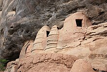
Granary on a rocky promontory in Niansogoni .
It is named after the river of the same name and the capital is Sindou .
The province is located in the extreme southwest of the country and is divided into the eight departments listed below. Agriculture is the main livelihood of the people of Léraba.
Location of the departments / municipalities
| map | No. | Department / municipality |
|---|---|---|
| 1 | Dakoro | |
| 2 | Douna | |
| 3 | Kankalaba | |
| 4th | Loumana | |
| 5 | Niankorodougou | |
| 6th | Ouéléni | |
| 7th | Sindou | |
| 8th | Wolonkoto |
Web links
- Monograph of the Léraba Province (French)
Individual evidence
- ↑ a b c Institut national de la statistique et de la demographie [INSD] (ed.): Annuaire statistique 2013 . December 2014, Tableau 01.01: List des communes par région et par province en 2013 , Tableau 02.17: Population et densité par région et province , Tableau 02.20: Population du Burkina Faso par province de 2001 à 2013 en milieu d'année , p. 5–6, 22–23, 32–35 (French, insd.bf [PDF; 3.2 MB ; accessed on February 27, 2015]).
