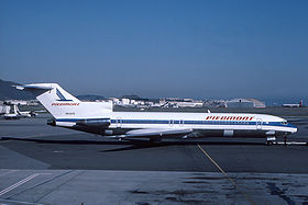
Piedmont Airlines Flight 22 Mar.
| Piedmont Airlines Flight 22 Mar. | |
|---|---|
|
A Piedmont Airlines Boeing 727 |
|
| Accident summary | |
| Accident type | Airplane collision in the air |
| place | Hendersonville , North Carolina , USA |
| date | July 19, 1967 |
| Fatalities | 82 |
| Injured | 0 |
| 1. Aircraft | |
| Aircraft type | Boeing 727-22 |
| operator | Piedmont Airlines |
| Mark | N68650 |
| Departure airport | Asheville Municipal Airport |
| Destination airport | Roanoke Municipal Airport |
| Passengers | 74 |
| crew | 5 |
| Survivors | 0 |
| 2. Aircraft | |
| Aircraft type | Cessna 310 |
| operator | Lanseair Inc. |
| Mark | N3121S |
| Departure airport | Charlotte Airport, NC |
| Destination airport | Asheville Municipal Airport |
| Passengers | 1 |
| crew | 2 |
| Survivors | 0 |
| Lists of aviation accidents | |
On July 19, 1967, a Boeing 727 took off from Asheville Municipal Airport in North Carolina on Piedmont Airlines Flight 22 to Roanoke Municipal Airport in Virginia . A short time later it collided with an approaching Cessna 310 . Both planes crashed, killing all 82 occupants. The main reason for the accident was that the Cessna deviated from its approved course, due to failure by air traffic control.
Planes
The affected aircraft of Piedmont Airlines was a four-year-old Boeing 727 to 22 with the air vehicle registration N68650, with three Pratt & Whitney JT8D equipped -7 engines and its first flight on May 22, 1963, after a total of 6,445 flight hours had passed. The Lanseair Inc. aircraft affected was a Cessna 310.
Crews
The captain of Flight 22 was the 49-year-old Raymond F. Schulte with a total of 18,434 hours of flight experience. The first mate was 30 year old Thomas C. Conrad with a total of 3,364 hours of experience. The flight engineer was the 37-year-old Lawrence C. Wilson with 281 hours of flight experience on the Boeing 727. The pilot in command of the Cessna was the 48-year-old John D. Addison, an employee of Radial Air, Inc. who was employed by Lanseair Inc. was rented. The other pilot was Robert E. Anderson, 36, an employee of Lanseair Inc.
course
In its investigation report published in September 1968, the US Accident Investigation Authority NTSB came to the following conclusions:
The Cessna 310 N3121S had taken off from Charlotte Airport, North Carolina at around 11:30 a.m. for its destination Asheville Municipal Airport , some 150 km to the west .
Flight 22 took off at 11:58 am from Runway 16 at Asheville Regional Airport for an instrument flight to Roanoke Municipal Airport in Virginia, with instructions from the air traffic controller to maintain the runway course until you pass 5000 ft (1524 m ) and then continue to 21,000 ft to rise. At 11:51 am, the pilots of the Cessna received the information to prepare for an ILS approach , which they did.
While the Boeing 727 was still taxiing, the Cessna confirmed that it had reached the rotating beacon (VOR) Asheville and was cleared to descend to 6000 ft (1830 m ). At 11:59:44, the air traffic controller cleared flight 22 for a further climb directly to VOR Asheville. Only after they had overflighted the VOR did he give the Cessna pilots clearance for an unexpected ADF- 2 approach to runway 16; this was a completely different procedure than the planned ILS approach.
The Boeing 727 was making a left turn when the collision between the Boeing 727 and the Cessna 310 occurred at an altitude of 6132 ft (1870 m ) at 12:01:18 p.m. This was not on the course prescribed for the ADF-2 approach.
The following were named as possible causes in the accident report: Confusion or misinterpretation on the part of the Cessna pilots, due to the very short-term change to a completely different approach procedure, or deliberate deviation from the last clearance.
In summary, the main cause was the deviation of the Cessna from its approved course, also due to insufficient flight preparation. The contributing cause was the failure of air traffic control to issue correct approach clearance in good time.
Web links
swell
Individual evidence
- ↑ Accident report Boeing 727 N68650 , Aviation Safety Network (English), accessed on November 30, 2016.
Coordinates: 35 ° 19 ′ 40.1 ″ N , 82 ° 27 ′ 35.4 ″ W.
