Place Moulin
| Place Moulin | |||||||||||
|---|---|---|---|---|---|---|---|---|---|---|---|
| The dam | |||||||||||
|
|||||||||||
|
|
|||||||||||
| Coordinates | 45 ° 53 '53 " N , 7 ° 29' 37" E | ||||||||||
| Data on the structure | |||||||||||
| Construction time: | 1955-1965 | ||||||||||
| Height of the barrier structure : | 155 m | ||||||||||
| Building volume: | 1.51 million m³ | ||||||||||
| Crown length: | 678 m | ||||||||||
| Crown width: | 6.43 m | ||||||||||
| Base width: | 47 m | ||||||||||
| Power plant output: | 130 MW | ||||||||||
| Data on the reservoir | |||||||||||
| Water surface | approx. 2 km² | ||||||||||
| Storage space | 107.78 million m³ | ||||||||||
| Catchment area | 137 km² | ||||||||||
| Particularities: | |||||||||||
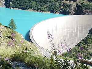
| Reservoir. The Prarayer refuge can be seen in the top left of the picture. | |||||||||||
The Place Moulin dam is a dam in Italy. It stands in a side valley of the Aosta Valley northeast of Aosta in the municipality of Bionaz and there dams the Buthier , a tributary of the Dora Baltea , with an arch dam to form a reservoir . The dam, which was built from 1955 to 1965, is 155 m high and is one of the largest dams on earth.
From the parking lot at the top of the dam, the Rifugio Prarayer refuge can be reached on a comfortable path after 1 hour of walking . The car park is also the starting point for the hike to the Rifugio Nacamuli al Col Collon .
See also
- List of the largest dams on earth
- List of the largest reservoirs on earth
- List of the largest hydroelectric plants in the world
- List of dams in the world # Italy
Web links
- the Place-Moulin dam (de, frz, it, eng)


