Place d'Armes (Montreal)
The Place d'Armes is a square in Montreal . It is located in the old town ( Vieux-Montréal ) in the arrondissement of Ville-Marie . The former Montreal parade ground is bordered on its southeast side by Rue Notre-Dame and on its northwest side by Rue Saint-Jacques .
Buildings
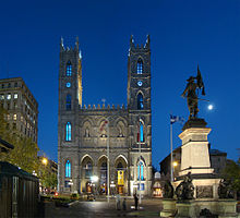
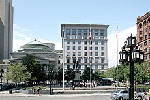
The buildings surrounding the square represent different eras of Montreal's architectural development. To the southeast, on the other side of Rue Notre-Dame, is the Notre-Dame de Montréal basilica , which was built from 1824 to 1829 and replaced the parish church of the same name. To the south of this is the Sulpizianerseminar ( Vieux Séminaire de Saint-Sulpice ) , built between 1684 and 1687 . Facing the basilica, on the opposite, northwest side of the square, is the classicist headquarters of the Bank of Montreal from 1859. Two early high-rise buildings are lined up on the northeast side, the neo-Romanesque Édifice New York Life (1889) and the Édifice Aldred (1931) as representatives of Art Deco. The southwest side is dominated by the 500 Place d'Armes skyscraper from 1968, which is 133 meters high and is the headquarters of the National Bank of Canada .
The Maisonneuve monument has stood in the middle of the square since 1895 . The work of the artist Louis-Philippe Hébert is reminiscent of Paul Chomedey de Maisonneuve , the founder of Montreal. The central figure of Maisonneuve is surrounded by depictions of Jeanne Mance , another important representative of the first settlers, and an Iroquois .
history
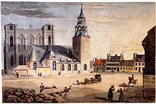
Place d'Armes is the second oldest public space in Montreal. In 1693, the Sulpizian order acquired the site northwest of the parish church of Notre-Dame, had it converted into a square and named it Place de la Fabrique . It soon developed into a popular meeting place. In 1721 the square was expanded and renamed Place d'Armes, as the militia exercised here. In 1760 the French garrison handed over their weapons to the advancing British troops on the square.
In 1770 the city's first statue was unveiled in the square. She presented the British King George III. five years later it disappeared without a trace and was finally found in a well shaft after several decades; today it is on display in the McCord Museum . From 1781 to 1813, the Place d'Armes was used as a hay and wood market. The city of Montreal acquired the square from the Sulpizians in 1836 and converted it into a Victorian- style garden . In 1914 the garden was completely removed. The last redesign so far took place in the years 2009 to 2011.
traffic
When the old town in the area of the Rue Saint-Jacques was still the financial center of Montreal, the Place d'Armes was an important junction of the tram network , with a depot in the Rue Saint-Antoine to the north. Initial plans for a subway included a station directly below the square. Today, line 2 runs a little further north, the Place-d'Armes station of Metro Montreal , which opened in 1966, is around 250 meters away. There is also access to the underground city .
Web links
- Architectural information (French)
- Historical photos and illustrations of the Place d'Armes (McCord Museum) (French)
Individual evidence
- ↑ a b c Place d'Armes. In: Vieux-Montréal. City of Montreal and Province of Québec, accessed September 30, 2011 (French).
- ↑ Réaménagement de la place d'Armes. (No longer available online.) In: Vieux-Montréal. City of Montreal and Province of Québec, archived from the original on October 27, 2012 ; Retrieved September 30, 2011 (French). Info: The archive link was inserted automatically and has not yet been checked. Please check the original and archive link according to the instructions and then remove this notice.
Coordinates: 45 ° 30 ′ 17.1 ″ N , 73 ° 33 ′ 25.7 ″ W.


