Rue Notre-Dame
The Rue Notre-Dame ( English Notre-Dame Street ) is a major street in Montreal . It starts in the Lachine arrondissement at Autoroute 20 . It then leads through the eastern part of the city center and the old town ( Vieux-Montréal ) and then follows the bank of the Saint Lawrence River to the northern tip of the Île de Montréal , where it ends after 35 kilometers. The Boulevard Saint-Laurent divides the street into a western and an eastern part.

history
At the beginning of the 1670s, the Sulpizian order , who at that time had the manorial power over the island, wanted to build a parish church. On this occasion, the street grid of the still young city should also be redefined. François Dollier de Casson , local head of the order, together with the surveyor Bénigne Basset, measured the new streets in 1672 and determined their names. The first was Rue Notre-Dame, which subsequently became the main axis of the old town.
The Rue Notre-Dame was initially limited to the section between the Rue de Bonsecours and the Rue McGill. In the course of the razing of the Montreal city walls (1804-1810) it was connected to the Rue Saint-Joseph in the southwest and the Rue Sainte-Marie in the northeast. After a city council decision in 1882, the entire street was given the uniform name of Rue Notre-Dame. It also coincided with the course of the Chemin du Roy , a road between the cities of Montreal and Québec , opened in 1737 .
Buildings
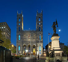
In the old town, Rue Notre-Dame passes numerous important buildings. These include the Hôtel de Ville , the Palais de Justice , the Château Ramezay , the Notre-Dame de Montréal Basilica , the Vieux Séminaire de Saint-Sulpice and the George-Etienne-Cartier House , the Tour de la Banque Royale and the Place d'Armes . North of the city center, it passes the Molson Brewery, the Port of Montreal and the Pointe-aux-Trembles windmill, among others .
More streets
In the western and central part, Rue Saint-Jacques runs parallel to Rue Notre-Dame. Major cross streets include the Rue Guy , the Rue Peel , the Rue University , the Rue McGill of Boulevard Saint-Laurent , the Rue Saint-Denis , the Boulevard Pie-IX , the Boulevard Viau and the Auto Route 25 .
literature
- Suzanne Lavigne, Nicole Rodrigue, Christiane Abboud: Les rues de Montréal: répertoire historique . Éditions du Méridien, Montreal 1995, ISBN 2-89415-139-X , p. 353-354 .
Web links
Coordinates: 45 ° 30 ′ 20.9 " N , 73 ° 33 ′ 21.6" W.


