Pletzergasse (Düren)
| Pletzergasse | |
|---|---|
| Street in Düren | |
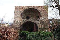
| The Pletzergasse tower | |
| Basic data | |
| place | Düren |
| District | Downtown |
| Created | 14th century |
| Connecting roads | At the Pletzerturm, Oberstrasse |
| Numbering system | Orientation numbering |
| Buildings | Pletzergasse tower |
| use | |
| User groups | Pedestrians, cyclists, motorists |
The Pletzer alley in the district town Düren ( North Rhine-Westphalia ) is one of its oldest historical urban roads .
location
The street leads from Oberstraße to Am Pletzerturm street . Opposite the confluence area is the listed Pletzergasse tower .
The street used to be within the city fortifications of Düren .
history
Pletzergasse was mentioned as early as 1355 and at that time led from Oberstraße in an easterly direction to the former Jesuit college, then turned at right angles to Kölnstraße . The street was also called Gertrudenstraße after the Nmanespronin of the Alexian or Cellitinnenkloster, which stood in the first section of the street. Part of the street facing Kölnstrasse was called Wurstgasse at times .
There is disagreement about the origin of the name. On the one hand Pletzer is derived from Plei , a place on the street, on the other hand the name is derived from Pletzer (inferior meat, sausage made from meat waste ).
literature
- Josef Geuenich: The Düren street names , Düren 1965, published by the city of Düren and the Düren history association
See also
Web links
- List of streets on the website of the city of Düren (PDF file; 56 kB)
Coordinates: 50 ° 48 ′ 7.1 ″ N , 6 ° 29 ′ 6.5 ″ E
