Pohuwato (Administrative Region)
| Kabupaten Pohuwato Pohuwato Governorate
|
||
|---|---|---|
 |
||
| Symbols | ||
|
||
| Basic data | ||
| Country | Indonesia | |
| province | Gorontalo | |
| Seat | Marisa | |
| surface | 4,244.3 km² | |
| Residents | 128,771 (2010) | |
| density | 30 inhabitants per km² | |
| ISO 3166-2 | ID-GO | |
| Website | www.pohuwatokab.go.id (Indonesian) | |
| politics | ||
| Bupati | Haji Syarif Mbuinga, S.Pd, MM | |
Coordinates: 0 ° 32 ' N , 121 ° 50' E
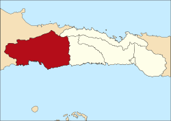
Pohuwato is a government district ( Kabupaten ) on the Indonesian island of Sulawesi . The district is part of the Gorontalo Province . 128,771 inhabitants live here (2010).
geography
Pohuwato has an area of 4,244.31 km². The capital is Marisa .
Administrative division
The Pohuwato district consists of 13 administrative districts ( Kecamatan ), three Kelurahan and 79 villages (Desa) (as of 2010):
| District | Population census 2010 |
|---|---|
| Popayato | 9,169 |
| Popatato Barat (West Popayato) |
6,670 |
| Popatato Timur (East Popayato) |
7,712 |
| Lemito | 10,488 |
| Wanggarasi | 4,573 |
| Marisa | 17,680 |
| Pantilanggio | 8,686 |
| Buntulia | 10,494 |
| Duhiadaa | 10,662 |
| Randangan | 14,995 |
| Taluditi | 7,248 |
| Paguat | 14,967 |
| Dengilo | 5,404 |
Individual evidence
- ^ Biro Pusat Statistics, Jakarta, 2011.

