
Polish fortress zone in East Upper Silesia

The Polish fortress zone in Eastern Upper Silesia (Polish: Obszar Warowny Śląsk) comprised a number of bunkers and other fortifications within Upper Silesia, which had been divided since 1920 . The plants were built in the interwar period in the Polish East Upper Silesia and stretched over a length of 60 kilometers from the village of Przeczyce in the north to Wyry (German Wyrow) in the south along the dividing line. The headquarters of the region was set up in Chorzów ( King's Hut ) and its commander was General Jan Jagmin-Sadowski .
photos

Bunker at Lagiewniki
Bunkered combat shelter No. 75 in Kochlowitz

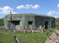
Bunker on Krzyżowa Street in Lagiewniki

Bunkered combat shelter No. 52 in Dobieszowice


