
Pont d'Arc

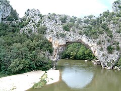
The Pont d'Arc is a natural stone bridge over the Ardèche River in the Ardèche department in southern France . It is 60 meters long, 54 meters high and is located about three kilometers from Vallon-Pont-d'Arc in the direction of Saint-Martin-d'Ardèche .
Emergence
The result is the Pont d'Arc, when the Ardèche in the Early Pleistocene at the narrowest point of a bend in the river, the Cirque d'Estre , the natural barrier of the limestone broke through the Cirque d'Estre put dry. Solid overhead rock was not removed so that the breakthrough was preserved as a stone bridge arch. The deep erosion of the river bed only occurred during the Messinian salinity crisis .
Surroundings
On the outer slope of the Cirque d'Estre is the Chauvet Cave , which houses Upper Paleolithic cave paintings and was included in the UNESCO World Heritage Site in June 2014 .

Pont d'Arc with canoeists on the Ardèche

in July 2004
in September 2006

Bathers in the Ardèche at the Pont d'Arc.


Web links
- Ardèche department: Tourist information on the Pont d'Arc. In: ardeche.com. Retrieved July 23, 2019 .
- Vallon Pont d'arc Tourist Office: The Pont d'Arc, a unique natural stone arch. In: pontdarc-ardeche.fr. Retrieved July 23, 2019 .
Individual evidence
- ↑ a b Ludovic Mocochain, Philippe Audra, Georges Clauzon, Olivier Bellier, Jean-Yves Bigot, Olivier Parize, Philippe Monteil: The effect of river dynamics induced by the Messinian Salinity Crisis on karst landscape and caves: Example of the Lower Ardèche river ( mid Rhône valley). In: Geomorphology , Volume 106, 2009, pp. 46-61.
Coordinates: 44 ° 22 ′ 55 ″ N , 4 ° 25 ′ 0 ″ E