
Pont de Tolbiac
The Pont de Tolbiac is a vehicle and pedestrian bridge in Paris .
Coordinates: 48 ° 49 ′ 58 " N , 2 ° 22 ′ 51" E
| Pont de Tolbiac | ||
|---|---|---|
 |
||
| use | Vehicular traffic, pedestrians | |
| Crossing of | His | |
| place | Paris | |
| Building number | 9318 | |
| overall length | 168 m | |
| width | 20 m | |
| Longest span | 35 m | |
| start of building | 1879 | |
| opening | 1882 | |
| location | ||
|
||

history
The building was decided in 1876 by the council of the city of Paris. Several designs were proposed for the construction of the bridge in 1879, including one by Gustave Eiffel . The two engineers HP Bernard and JDA Pérouse won .
In 1890 the bridge was damaged by January ice on the Seine and rebuilt in 1893.
In 1943 an Allied bomber attacked the Chevilly-Larue power plant and was hit by the German air defense. In order not to fall into the city, the pilot Yves François Lamy flew in the direction of the Seine, whereupon he hit the Pont de Tolbiac and sank into the Seine. None of the four crew members who belonged to the French army survived this disaster. Today a marble plaque on the bridge commemorates this event.
Data
The bridge is 168 meters long, 20 meters wide and consists of five elliptical arches measuring 29, 32, 35, 32 and 29 meters. The street is 12 meters wide and surrounded by two four meter wide sidewalks.
location
The bridge is located in the 12th and 13th arrondissements of Paris. The access roads are Rue Joseph Kessel and Rue Neuve Tolbiac. The next station of the Métro Paris is the Cour Saint-Émilion station.
gallery

Memorial plaque

Memorial plaque
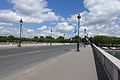
Bridge lanes

Masonry of the bridge

Detail view of an arch
,_Pont_de_Tolbiac,_Paris.jpg)
,_Pont_de_Tolbiac,_Paris.jpg)
.jpg)


See also
Web links
Individual evidence
- ↑ Le pont de Tolbiac. In: Histoires de Paris. December 23, 2016, accessed on March 28, 2020 (fr-fr).
- ↑ a b Pont de Tolbiac | Le Rendez Vous du Mathurin. Retrieved March 28, 2020 .