
Prerower electricity
The Prerower Strom , Prerow-Strom or Prerowstrom is a body of water on the lagoon coast of Fischland-Darß-Zingst , which largely separates the Darß from the Zingst peninsula . It begins at the Schmidtbülten island in Bodstedter Bodden and winds from there in a north-westerly direction to almost the (outer) Baltic Sea coast at Prerower Bay. Shortly before its northern end is the inland port of the eponymous town of Prerow . The Prerower Strom belongs to the Vorpommersche Boddenlandschaft National Park .
history
The Prerower Strom is not a river, but a former sea channel that was only created in the first millennium AD, when the Zingst began to fall dry permanently. In strong onshore winds, a lot of sediment-bearing water flowed through the Prerower Strom into the Bodstedter Bodden, which gradually caused the Schmidtbülten to be piled up as part of a rear delta. Until the 19th century, the Prerower Strom connected the bay with the open sea and was up to 10.35 kilometers long. In 1872, however, there was a severe storm flood in the area , during which the northern part of the river silted up at Prerow and as a result was artificially filled in and secured by dykes. By cutting off the current from the Baltic Sea, the formation of the rear delta has come to a standstill.
The Prerower Strom nowadays
Today's Prerower Strom is divided into four sections, all of which are separated by road embankments and connected to one another by small canals. They are on average up to 3 meters deep.
By far the longest part is around 7 kilometers long and extends from Bodden to Landesstraße 21 (L 21), the so-called Bäderstraße in Prerow. The other three sections are to the west of this road, on the northern edge of Prerow. In fact, there are three elongated lakes, each 500 to 700 meters long.
Boat trips, leisure time and "folk festival"
On the main arm of the Prerower Strom you can drive from Prerow to several places on the Fischland-Darß-Zingst peninsula and the nearby mainland. This is possible with both ferries and passenger ships.
On the middle of the western lakes, accessible via the road that leads to the pier in the Baltic Sea, you can also go pedal boating and fishing. On the southwest corner of this lake, on the shopping street by the boat rental, there are also some candy stalls, a swing boat and a carousel. This is why the locals also refer to this area as the “folk festival”. Further north, towards the pier, the shopping street, which is only allowed to be used to a limited extent from here, develops into the busiest street on the peninsula due to around 20 souvenir and specialty shops.
The Prerower Strom with Prerower Harbor in the background

The Prerower Strom between Zingst and Darß

Aerial view of the Prerower Strom with Prerow, its harbor, the Strom lakes, the state road and the pier

One of the northern stream lakes

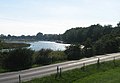
The Prerower Strom seen from the narrowest point to the Baltic Sea towards the Bodden


Coordinates: 54 ° 26 ′ 4 ″ N , 12 ° 37 ′ 16 ″ E