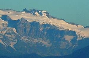
Puyallup Glacier
| Puyallup Glacier
( Puyallup Glacier )
|
||
|---|---|---|
|
Puyallup Glacier and Puyallup Cleaver |
||
| location | Pierce County , Washington , USA | |
| Mountains | Cascade chain | |
| Type | Kar glacier | |
| surface | 5.2 km² (1983) | |
| Altitude range | 2591 m - 1829 m | |
| Ice volume | 0.289 km³ | |
| Coordinates | 46 ° 50 '59 " N , 121 ° 49' 27" W | |
|
|
||
| drainage | Puyallup River | |
The Puyallup Glacier is a glacier on the western flank of Mount Rainier in Washington state . In 1983 it covered 5.2 km² and contained about 289 million m³ of ice. Since it shares the same ice spring as the South Mowich Glacier to the north, the Puyallup Glacier begins as a branch of the ice stream that leaves the Sunset Amphitheater . From the split at about 8,500 ft (2,591 m) elevation, the glacier expands in a broad ice sheet ranging from 8,400 ft (2,560 m) to 7,400 ft (2,256 m) in height. After leaving this extension, the glacier flows down a small valley that visibly narrows when it turns west-northwest. From there on, the glacier gets a dirty look and ends on steep, uneven terrain at about 6,000 ft (1,829 m) altitude. The glacier is the source of the Puyallup River .
Individual evidence
- ↑ a b c DESCRIPTION: Mount Rainier Glaciers and Glaciations - Mount Rainier Glacier Hazards and Glacial Outburst Floods . USGS. Retrieved November 19, 2007.
- ↑ a b Puyallup Glacier, USGS Mount Rainier West (WA) Topo Map . In: USGS Quad maps . TopoQuest.com. Retrieved May 17, 2008.

