Quarantine Island
| Quarantine Island | ||
|---|---|---|
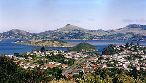
| View over Port Chalmers to the Otago Peninsula . Quarantine Island is visible on the left side of the picture, Goat Island in the middle | ||
| Waters | Otago Harbor , Pacific Ocean | |
| Geographical location | 45 ° 49 ′ 41 ″ S , 170 ° 38 ′ 0 ″ E | |
|
|
||
| surface | 15 ha | |
| Quarantine Island from above the Portobello Marine Laboratory on the Otago Peninsula . The remaining building of the quarantine quarter is the two-story building in the middle. In 2010 it was secured as part of the restoration work | ||
Quarantine Island / Kamau Taurua is the largest island in Otago Harbor near the city of Dunedin , New Zealand .
The island has an area of 15 hectares and is largely a public recreational area. The main buildings are on the New Zealand Historic Places Trust list.
The smaller island of Goat Island / Rangiriri is close to Quarantine Island. Both islands are opposite the harbor between the town of Port Chalmers and the Portobello Marine Laboratory on the Portobello Peninsula .
history
Between 1863 and 1924 the island served as a quarantine station for ships arriving in Otago. If the crews had infectious diseases, they were sent to the island until they got better or until they died. There is a small cemetery on the island. After the quarantine station was closed, the island was leased. The St Martin Island Community has been using the island for work and worship since 1958. During this time the island was afforested .
As part of the agreement with the Ngāi Tahu in 1996, the island was given the original Māori name Kamau Taurua as part of the official name , in German place to set up nets .
Only a single quarantine building has been preserved and is currently (2010) being restored.
literature
- Neville Peat, Brian Patrick: Wild Dunedin . The natural history of New Zealand's wildlife capital. Otago University Press, Dunedin 2014, ISBN 978-1-877578-62-5 (English).
- Pamela McGeorge: New Zealand's Islands . Bateman, 2004, ISBN 978-1-86953-586-5 (English).
- Joyce Herd & GJ Griffiths: Discovering Dunedin . John McIndoe, Dunedin 1980, ISBN 978-0-86868-030-9 (English).
- Lyndall Hancock: Quarantine Island / Kamau Taurua (St Martin Island) A short history . St Martin Island Community, Dunedin 2008, ISBN 978-0-473-14209-4 (English).
Web links
- Eileen McSaveney: Nearshore islands. In: Te Ara - the Encyclopedia of New Zealand. Ministry for Culture & Heritage, July 13, 2012, accessed January 23, 2016 .
Individual evidence
- ^ Quarantine Island / Kamau Taurua Historic Area. Historic Area. In: New Zealand Heritage List / Rārangi Kōrero . Heritage New Zealand Pouhere Taonga , December 7, 2001, accessed September 23, 2019 .
- ↑ Place Name Detail: Quarantine Island / Kamau Taurua . New Zealand Geographic Placenames Database. Country information New Zealand. January 24, 2009.


