Otago Peninsula
| Otago Peninsula | ||
 Dunedin, Otago Peninsula and Otago Harbor |
||
| Geographical location | ||
|
|
||
| Coordinates | 45 ° 51 ′ S , 170 ° 39 ′ E | |
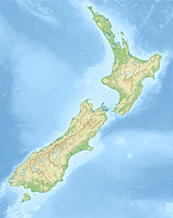
| location | Dunedin on the southeast coast of the South Island , Otago Region , New Zealand | |
| Waters 1 | Pacific Ocean | |
| Waters 2 | Otago Harbor | |
| length | 30 km | |
| width | 12 km | |
The Otago Peninsula is a 30 km long and up to 12 km wide peninsula on the South Island of New Zealand and part of the Southern Scenic Route . The peninsula is located in the urban area of Dunedin and extends from the city center in a north-easterly direction, directly on the Pacific Ocean .
Originally the eastern part of the crater rim of a collapsed volcano , with all its foothills, the peninsula with its varied landscape and many different terrain forms provides fascinating insights into valleys, bays, the ocean and Otago Harbor .
geology
The Otago Peninsula was formed during the three major eruption phases of the volcano, which was active 11-13 million years ago and had its eruption center between what is now Port Chalmers and Portobello . The volcano formed out of the sea, directly on the coast of the then still flat landscape. Designed as a shield volcano , the very thin lava flowed mainly in two directions, following the bed of today's Otago Harbor. At its best, the volcano reached a height of approx. 1,000 meters and shaped the landscape accordingly with its up to 200 cores that were active at different times . After the collapse of the volcano and the erosion that took effect over millions of years , the sometimes gentle and rugged landscape was created as it is today. Originally formed as an island, however, the southwestern part of the lava bed lying below sea level silted up and connected to the "mainland". Today, this is where Dunedin's city center is located.
From the highest elevations on the peninsula (just over 400 meters) it goes steeply over the cliffs up to 100 meters high down to the Pacific Ocean. On the coast, cliffs alternate with small and large sandy bays and the protected shallow water areas, the so-called inlets. Towards Otago Harbor, the slopes drop more gently, which promoted settlement on this part of the peninsula.
history
Early settlement
The archaeologists date the first settlement of the Otago -Küstenregion 1100 n. Chr. By the Polynesians , the later Māori called what the meaning of the word means as much as natural , normal or locally . It has not yet been possible to determine exactly when the Otago Peninsula was settled. It is believed, however, that the first verifiable evidence comes from the 15th century. Finds of remains from earth ovens in the large sandy bay of Okia Flat in Wickliffe Bay show that Māori had settled here .
European settlement
On a summer afternoon on February 24, 1770, Captain James Cook sailed the Endeavor along the Otago Peninsula. He named a significant high point on the Mount Charles peninsula and a cliff protruding below it, Cape Saunders , in honor of Sir Charles Saunders , commander of the British fleet in Québec in 1759. It was the first sighting of the peninsula by a European .
Cook's notes that there were plentiful seal colonies on the Otago coast quickly brought seal and whale hunters over from Australia , who found good hunting grounds here. Seal hunter John Boultbee was the first to document the settlements around Otago Harbor in the 1820s. In 1831 the Weller brothers came over from Sydney and founded a whaling station in a bay of Otago Harbor, not far from the settlement of Ōtākou . This place is known today as Wellers Rock . With the landing of the first Scottish settlers, 1848 can be seen as a turning point from whaling to organized settlement.
With the arrival of the Europeans, diseases and infirmities came to the Māori , which caused the population, already decimated by tribal feuds, to decrease further. Around 1848 the inhabitants of the Māori settlement Otakau still numbered a little over 100 inhabitants. When Reverend Thomas Burns visited the Ngai Tahu in their settlement Ōtākou in 1848 after his arrival , he was shocked by the living conditions there. From now on the living conditions of the Maori population in this area should improve somewhat.
Settlement from 1848
With the organized settlement of the Otago region by the Europeans, there were dramatic changes for the flora and fauna of the Otago Peninsula. Even if the structure of the terrain remained essentially unchanged, the forest and the bush landscape were cleared for cattle breeding and dairy farming wherever it seemed possible and economical. Trees, bushes and native plants fell victim to the planting of exotic grasslands. Small dairies , organized as cooperatives , sprang up like mushrooms. New Zealand's first dairy cooperative was established in Springfield on the peninsula in 1871 . Many of the largest dairy companies ( Sandymouth, Wickliffe Bay, Lower Portobello, Ōtākou and Pukehiki creameries ) supplied Dunedin directly with their dairy products.
After the turn of the century (1900), the Otago Peninsula received more and more visitors from those looking for relaxation and leisure. Portobello, Broad Bay, Macandrew Bay and Hoppers Inlet became important recreational areas for Dunedin. Around 1914 the change from dairy farming to sheep breeding began, which brought in more money and enabled the Peninsula Country Council (council, administration) to finally make the roads and roads more passable. Local recreational tourism also had a positive influence on the improvement of the infrastructure . Portobello, Broad Bay and Macandrew Bay quickly grew into small settlements and Macandrew Bay became known for its sailing regattas . The Otago Peninsula also slowly became interesting as a residence for wealthy people. The best-known example of this is the banker William Larnach , who built the mansion Larnach Castle , which is the only castle in New Zealand's history, to be built in 1871 and who lived there with his family until his bankruptcy and subsequent suicide.
Overall, the proportion of the farm population declined from the turn of the century and the proportion of commuters to Dunedin residing on the peninsula increased. However, the population growth was limited, so that in the 1960s only around 3,500 inhabitants were counted on the peninsula, compared to around 2,000 in the 1870s.
The Otago Peninsula is still used for agriculture today, but at the same time, as a residential and recreational refuge with high tourist, leisure and educational value, it is Dunedin's greatest scenic attraction.
Attractions
Seen from the northeast tip of Taiaroa Head to Dunedin:
Taiaroa Head
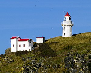
The 80 m high Taiaroa Head is a rocky cliff on the northeastern tip of the Otago Peninsula. The cliff is right at the entrance of the Otago Harbor . Originally called Pukekura by the Māori , European settlers renamed this cliff to Taiaroa Head after the leader of the Ngai Tahu , Te Matenga Taiaroa (1783–1863, Ōtākou ) .
- Lighthouse - The 12 meter high lighthouse , which is still located today, was built here as the most important strategic point in 1864 . The gold rush in Otago , which boosted Dunedin and the Otago region economically and culturally, made construction necessary and provided the financial means for it. Today equipped with modern radar , the lighthouse is subordinate to the Navy Ministry and can only be admired from the outside.
- Fort Taiaroa - From 1885 on, Taiaroa Head was expanded into a small fortress with underground passages and six cannon batteries. The political tensions in Asia and the two wars, the Sino -Japanese War (1894–1895) and the Russo-Japanese War (1904–1905), led to increased militarism in New Zealand and consequently to the construction of the fort .
- Royal Albatross Colony - Between 1914 and 1919, the first species of Northern King Albatross ( Diomedea sanfordi ) were sighted at Taiaroa Head and in 1920 the first egg was found as evidence that the birds were breeding here. In 1937 Lancelot Eric Richdale , an ornithologist from Dunedin, began to study the birds, which can fly at speeds of up to 115 km / h with their wingspan of up to 3 meters, and to protect them from external influences. In 1951 the first full-time bird warden was employed with the care and rearing of the birds. Today, the Royal Albatross Center is a research and care station that also gives visitors the opportunity to observe the seabirds , which appear majestic in flight, up close.
Penguin Beach
Not far from Taiaroa Head, 1.5 km south on Penguin Beach, the rare yellow-eyed penguins ( Megadyptes antipodes ) have their habitat. Classified as an endangered species, the animals up to 60 cm in size are specially protected on the coast of the Otago Peninsula. Visitors can come very close to the animals on guided tours and hidden in shelters without bothering them.
Ōtākou
Following the embankment, about 5 km from Taiaroa Head, those interested will find a marae (meeting place) with the Whare Runanga (meeting house) and a Māori church from 1864 in the historically significant Māori settlement Ōtākou Before is inhabited by Māori , tourists do well to book in advance.
Marine Studies Center
The New Zealand Marine Studies Center is part of the University of Otago and is located on a small peninsula near Portobello that protrudes into Otago Harbor. Not only marine research is carried out here. A marine exhibition with an attached marine aquarium is open to interested visitors. The small sharks get special attention - and they are extremely popular with children . Some marine animals can even be touched.
Harbor Cone
Approximately in the middle of the peninsula is the Harbor Cone ( Māori : Tere Weka ), the highest elevation, an almost perfectly formed cone made of volcanic basalt , which is a remnant from volcanic times as a plug of a volcanic crater . Gold was also found here in the 1870s, resulting in limited mining from a 13 meter deep shaft.
Larnach Castle
Larnach Castle , built in 1871 by the banker and politician William Larnach , is often referred to as the only castle in New Zealand. 200 workers were busy building the core of the building for 3 years. European craftsmen needed another 12 years for the interior work, in which a wide variety of materials from many European countries were used. Larnach's fortune as a banker, amassed in the emerging Dunedin of his day, made this flaunted luxury possible. After Larnach's bankruptcy and subsequent suicide in 1898, the house fell into ruin . In 1967 Margaret Barker and her family bought the property and painstakingly restored it over many years, finally opening it to visitors. In addition to the building, the interior, the well-tended botanical garden and the impressive view from the tower-like roof of the house are remarkable .
Lime Kiln
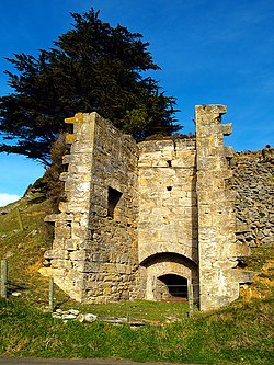
As historical buildings of the region, not far from Harbor Cone in the middle of the peninsula, three partially preserved Lime Kilns ( lime kilns ) can be visited. In the 1860s, limestone was intensively burned here, which was broken from the surrounding hills. At the turn of the century, operations were discontinued for economic reasons. The buildings are under monument protection.
Sandymount Hill
Sandymount Hill is the highest point of the southern coastal area with steep cliffs and a fantastic view of the Pacific Ocean and the coast of the Otago Peninsula.
Fletcher House
The building contractor James Fletcher built a house on the quayside to Portobello in 1909 in the style of the Edwardian period (1901-1910). The house was completely restored from 1991 to 1992. Like a journey back in time, the house realistically shows the lifestyle of the middle class in New Zealand shortly after the turn of the century.
Glenfalloch Garden
The Glenfalloch Garden ( translated from Gaelic : hidden valley ) is located not far from Macandrew Bay in a small protected valley and has its own microclimate , which extends the seasons and thus promotes plant growth. The forest and garden landscape, which has almost been returned to its original state, has been officially assessed as a "garden of national importance". 120 years of development and gardening show native and imported plant species in harmony with one another.
Highcliff Road
The Highcliff Road leads over the ridge of the Otago Peninsula from Waverly , Dunedin to Portobello and offers alternating fascinating views of the coastal landscape and Otago Harbor with the hills around Mount Cargill behind .
hikes
The Otago Peninsula gives hikers an excellent opportunity to experience the cultural landscape of the peninsula and its history. The topographic map No. 260-I44 & J44 (see sources) can be used as suitable map material.
literature
- Hardwicke Knight: Otago Peninsula - A Local History . Dunedin 1978 (English, Author's Edition, No. 113, signed limited edition of 200 copies, Broad Bay, Otago Peninsula, Dunedin).
- Hardwicke Knight: ohannes des Vries: Known The Region, Drive 6 . Otago Regional Committee, Dunedin 1971 (English).
- Neville Peat: Southern Land, Southern People - Otago Museum's Landmark Gallery . University of Otago Press, Dunedin 2002, ISBN 1-877276-16-2 (English).
- PJ Forsyth: The Dunedin Vulcano . New Zealand Geological Survey, 1985 (English).
- Dunedin Map, 1: 50,000, 260-I44 & J44 . Land Information New Zealand, Wellington 2002 (English).
Web links
- Homepage. Yellow-eyed Penguin Trust, accessed September 3, 2014 .
- Marine Studies Center. University of Otago, accessed January 6, 2016 .
Individual evidence
- ^ Royal Albatross Colony. Royal Albatross Center, archived from the original on June 15, 2008 ; accessed on January 6, 2016 (English, original website no longer available).
- ^ Marine Studies Center. University of Otago, accessed January 6, 2016 .


