
Southern Scenic Route

The Southern Scenic Route is a tourist route in the south of New Zealand's South Island . The approximately 610 km long route connects Queenstown with the Fiordland and Te Anau via Manapouri and Riverton with Invercargill and Bluff . From there it leads through the Catlins to Balclutha and Dunedin .
Routing

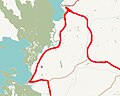
The Southern Scenic Route follows a U-shaped route.
From Queenstown it takes you on State Highway 6 and from Mossburn on State Highway 94 to Te Anau.
Although the Milford Sound is not an official part of the route, a trip to the Sound is recommended starting from Te Anau (see also detour ).
From Te Anau it follows the eastern border of the Fiordland National Park through Manapouri and Tuatapere . It reaches the coast at Te Waewae Bay and turns southeast through Orepuki , Colac Bay and Riverton.
In Lorneville , the road returns to State Highway 6 and follows it through the town of Invercargill. Bluff can be reached via State Highway 1 via a detour.
From Bluff, Stewart Island can be reached as an extended destination on the route as recommended in the information brochure (see also detour ).
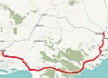
From Invercargill the road turns east through Fortrose into the Catlins, then through Owaka to Balclutha. The next rugged stretch of coast with its bad roads around Kaitangata is bypassed, the Southern Scenic Route follows the course of State Highway 1 to Milton and Lake Waihola .
At Waihola the route leaves the highway again and climbs up through the Otago Coast Forest ; it reaches the coast again at Taieri Mouth . From here the road follows the back road through Brighton and Green Island . It ends at Caversham in SH1.
History and Development

The concept and name of the Southern Scenic Route originated at an informal meeting in Tuatapere in November 1985 and was confirmed at a public meeting in January 1986. The project sponsors then negotiated with the tourism and road authorities and the local government.
As it was the first such project in New Zealand, the approval process made slow progress. The Southern Scenic Route was officially opened on November 6, 1988 and led from Te Anau to Balclutha. The line was extended to Dunedin in 1998.
At the beginning of 2007 the idea came up to extend the route beyond Dunedin through Waikati . In November 2007, Dunedin City Council confirmed that it was negotiating with the Waitaki District Council to extend it to Oamaru . Until the end of 2010 these ideas were not implemented.
The road is maintained in its individual sections by the New Zealand Transport Agency , the Southland District , the Clutha District and the cities of Invercargill and Dunedin.
The route itself uses paved roads throughout; however, many of the sights that are accessed by the Southern Scenic Route are not directly on the road and can only be reached via unpaved roads and hiking trails.
Travel + Leisure magazine described the route in 2008 as "one of the greatest undiscovered routes in the world".
Stages and stations
The information brochure for the route lists over 80 stations on 7 stages, which include sights in nature as well as buildings, hiking opportunities, historical places or places where wildlife can be observed.

Stage 1 - Queenstown and Wakatipu
Stage 2 - Fiordland, Te Anau and Manapouri

Stage 3 - Western Southland

Stage 4 - Invercargill and Bluff
Stage 5 - The Catlins

Stage 6 - Balclutha

Stage 7 - Dunedin and Otago Peninsula


Queenstown and Wakatipu
Starting in Queenstown , the route leads over Kingston and Five Rivers to Mossburn . This section primarily lists hiking options as stations.
| Type and location | designation | description | image | |
|---|---|---|---|---|
| 1 | Hike |
Queenstown Hill Time Walk | A hike at the end of which a 360 degree view of the Queenstown area is possible. |

|
| 2 | Hike | Queenstown Gardens | A thirty minute circuit to the Frankton Arm . | |
| 3 | Hike | Frankton Arm Walkway | The Frankton Arm Walkway is a cycling route between Queenstown and Frankton . |

|
| 4th | Hike |
Kelvin Peninsula Track | A riverside path that leads from the Kawarau Falls Bridge along the Frankton Arm . |

|
| 5 | Hike |
Jack's Point Track | A hike along Lake Wakatipu that has good views of the lake and mountains. |

|
| 6th | Hike |
Lower Wye Creek Track | A hike to Lower Wye Creek , which takes about four hours to get there and back. | |
| 7th | Lookout point |
The Devil's Staircase | A lookout point that allows views of Lake Wakatipu. |

|
| 8th | Hike | The Shirtail Track | A hiking trail that leads to Shirtail Creek . | |
| 9 | Hike | The Lakefront Track | A riverside path starting in the Kingston Lakefront Reserve . | |
| 10 | Sight / hike |
Remarkables Conservation Area | The Remarkables are a mountain range up to 2,340 meters high, on which there is a ski area. |

|
Fiordland, Te Anau and Manapouri
Coming from Mossburn , the route describes an arc via Te Anau to Manapouri , both places which represent entry points for the New Zealand Fiordland National Park . In this area hiking opportunities as well as beaches and a lookout point are listed as stations. From Te Anau, a detour to Milford Sound is recommended, but it is not part of the route (see detour ).
| Type and location | designation | description | image | |
|---|---|---|---|---|
| 1 | Hike | From the visitor center to the Te Anau Wildlife Center | A bank hike to the Te Anau Wildlife Center . |

|
| 2 | Hike | From the visitor center to the control gate | A 50 minute hike to the Control Gates on the southwest side of Lake Te Anau . | |
| 3 | Hike |
From the control gate to the dock bay | There is a hike from the Control Gates to Dock Bay where you can swim. | |
| 4th | Hike |
From the control gate to Brod Bay | A hike from the Control Gates to Brod Bay, from where a return trip by water taxi to Te Anau is possible. | |
| 5 | Hike |
From Rainbow Reach to Shallow Bay | A forest hiking trail on which some of the Lord of the Rings filming locations are located. | |
| 6th | Lookout point | Wilderness lookout | A viewing platform that allows a panoramic view of the surrounding landscape. | |
| 7th | Beach | Frasers Beach | A 45 minute hike from Pearl Harbor to Frasers Beach. |

|
Western Southland
This section is located between Manapouri and Riverton and offers hiking opportunities, viewpoints, natural sights and historical sites as stops on the Southern Scenic Route.
| Type and location | designation | description | image | |
|---|---|---|---|---|
| 1 | Sightseeing | Rakatu Wetlands and Redcliff Wildlife Reserve | A wetland with a variety of hiking opportunities. |

|
| 2 | Hike |
Borland Road and Borland Lodge | The Borland Road is one for four-wheel drives suitable road into the hinterland. | |
| 3 | Hike | Borland Nature Walk | A hike starting from Borland Lodge . | |
| 4th | lake |
Lake Monowai | Lake Monowai is a lake in the southern part of Fiordland National Park . |

|
| 5 | Lookout point | The Peninsula Lookout | A lookout point that overlooks Lake Monowai. | |
| 6th | Hike | Big Totara Walk | A hiking trail that leads past Totara Trees that are over 1000 years old . | |
| 7th | Sightseeing |
Clifden Suspension Bridge | A bridge built in 1898. |

|
| 8th | cave | Clifden Caves | A system of limestone caves that can be entered. | |
| 9 | lake |
Lake Hauroko | Lake Hauroko is 462 meters deep and is New Zealand's deepest lake. |

|
| 10 | Hike | Tuatapere Hump Ridge Track | The Tuatapere Hump Ridge Track is a 55-kilometer hiking trail over the Hump Ridge . | |
| 11 | Sightseeing | Port Craig | A former lumberjack town, which can be explored by means of a historical nature trail (Heritage trail). | |
| 12 | Lookout point | McCracken's rest | A viewing platform with views of Te Waewae Bay and the Solander Islands . | |
| 13 | Beach | Gemstone Beach | A beach where minerals such as quartz can often be found. | |
| 14th | island |
Monkey Island / Te Puka o Takitimu | A small island that can be entered at low tide . |

|
| 15th | bay |
Cozy Nook | A rocky bay and the former location of a Maori settlement. | |
| 16 | Hike | Long Hilly Track | A hike to see the relics of Chinese prospectors. | |
| 17th | bay |
Colac Bay / Oraka | A small settlement on a bay with good surfing conditions . | |
| 18th | Hike | Mores Scenic Reserve | The Mores Scenic Reverse contains numerous hiking opportunities. | |
| 19th | Hike | Taramea / Howells Point | An area that offers opportunities for hiking, fishing and picnicking. | |
| 20th | Hike | Te Wai Korari Wetland Reserve | A hike through the Te Wai Korari Wetland Reserve . |
Invercargill and Bluff
The Southern Scenic Route connects Riverton with Invercargill on this section , makes a detour to Bluff and then continues from Invercargill on the Gorge Road-Invercargill Highway towards Balclutha . In addition to sights in and around Invercargill and Bluff, a detour to Stewart Island is recommended (see detour ).
| Type and location | designation | description | image | |
|---|---|---|---|---|
| 1 | Sightseeing |
Invercargill Water Tower | The 40 meter high historic water tower was completed in 1889 and offers a good view of Invercargill. |

|
| 2 | Hike |
Thomson's Bush | A former marshland that offers hiking and picnic opportunities. | |
| 3 | Hike |
Waihopai Walkway | A hike along the Waihopai River . | |
| 4th | Sightseeing | Anderson Park Art Gallery | The Anderson Park Art Gallery is an art collection housed in a Georgian-style property. | |
| 5 | Sight / hike |
Sandy Point / Oue | An area that offers various possibilities for excursions and hikes. | |
| 6th | Beach |
Oreti Beach | The 30 km long Oreti Beach is part of a route to Riverton that was formerly used by Maori . |

|
| 7th | Hike |
Greenpoint Reserve | A hike that is designed as a nature trail. | |
| 8th | Sight / hike | Bluff Hill / Motupohue and Stirling Point | The Bluff Hill has special cultural significance for Maori, and can be accessed by different trails. |

|
| 9 | Sight / hike | Waituna Wetlands | The Waituna Wetlands is a significant area for various bird, fish and plant species. |
The Catlins
A longer section of the route leads along the coast through the Catlins to Balclutha . In this section, waterfalls, beaches and bays particularly characterize the stops on the route.
| Type and location | designation | description | image | |
|---|---|---|---|---|
| 1 | Sightseeing |
Waipapa Point | Waipapa Point is a rocky cape with a lighthouse. In 1881 the steamship Tararua capsized here . With 131 fatalities, this was the worst disaster for civil shipping in New Zealand to date. |

|
| 2 | Sightseeing |
Tararua Acre Cemetery | Many of the victims of the shipwreck at Waipapa Point are buried in Tararua Acre Cemetery. | |
| 3 | Sightseeing |
Slope Point | The Slope Point is the southernmost point of the New Zealand South Island . |

|
| 4th | Sight / hike |
Waipohatu Recreation Area | The Waipohatu Rectreation Area is a forest area that offers various hiking opportunities. | |
| 5 | bay |
Curio Bay / Tumu Toka and Porpoise Bay | Curio Bay is a cove with a petrified forest that is accessible at low tide. The nearby Porpoise Bay is a popular seaside resort. |

|
| 6th | Sightseeing |
Waikawa | Waikawa is a small port town with a settler museum and the starting point for various hikes in the area. | |
| 7th | waterfall | Niagara Falls / Manga Piri | A small waterfall named after the American Niagara Falls . | |
| 8th | waterfall | McLean Falls | The McLean Falls are 22 meters high and are located on the Tautuku River . |

|
| 9 | cave |
Cathedral Caves | The Cathedral Caves are a series of touristically developed coastal caves up to 30 meters high. |

|
| 10 | Sight / hike | Lenz reserve | The Lenz Reserve is a nature reserve that offers various options for hiking. | |
| 11 | Hike |
Tautuku Estuary Boardwalk | A hiking trail of around 30 minutes, some of which is laid out as a wooden walkway. | |
| 12 | lake |
Lake Wilkie | Near Lake Wilkie there is a nature trail that describes the progress of the siltation . |

|
| 13 | bay |
Tautuku Bay | Tautuku Bay is a bay that borders the Tautuku Peninsula in the west. There was a whaling station there in the 1830s and 1840s. |

|
| 14th | Lookout point |
Florence Hill Lookout | A vantage point from which Tautuku Bay and the Tautuku Peninsula can be seen. | |
| 15th | Hike | Coastal Walking Tracks | The Papatowai Scenic Reserve offers various hiking trails as well as wildlife viewing opportunities. | |
| 16 | Hike | Old Coach Road | A 40 minute hike along Old Coach Road , which starts at the Tahakopa River Bridge. | |
| 17th | waterfall | Matai Falls | The Matai Falls are a 10 meter high waterfall on the Matai Stream in Catlins Forest Park . | |
| 18th | waterfall |
Purakaunui Falls | The Purakanui Falls are located on the Purakanui River and are 20 meters high. They are considered the symbol of the Catlins. |

|
| 19th | Hike | Catlins River Walk | A hike that runs along the Purakanui River and includes numerous river crossings on suspension bridges . | |
| 20th | Sightseeing |
Jack's blowhole | A 55 meter deep blowhole named after a former Maori chief . |

|
| 21st | Hike | Pounawea Bush Walk Track | A hike of around 45 minutes, including a salt marsh . | |
| 22nd | Sight / hike |
Surat Bay Wildlife Walk | Surat Bay is a popular stopover for New Zealand sea lions that can be seen here. |

|
| 23 | Sightseeing | Tunnel Hill | A former railway tunnel that was built between 1891 and 1892. | |
| 24 | Sightseeing |
Roaring Bay | In addition to various seabirds, you can also watch New Zealand fur seals and yellow-eyed penguins in Roaring Bay . |

|
| 25th | Sightseeing |
Nugget Point / Tokata Lighthouse | The Cape Nugget Point is home to numerous sea birds and a large colony of New Zealand fur seals. The existing lighthouse of the same name was completed in 1869. |

|
| 26th | Hike |
Kaka Point Bush Walk | About a 30 minute hike that starts near Kaka Point. | |
| 27 | Hike | Awakiki track | A 40 minute hike through the Awakiki Reserve . |
Balclutha
The course of the route leads on this section coming from the coast via Balclutha to Milton and from there taking the coastal road again to Dunedin . Historical sights, special points in nature, as well as hiking opportunities can be found on this section.
| Type and location | designation | description | image | |
|---|---|---|---|---|
| 1 | Hike |
Naish Park / Blair Athol Walkway | About a two hour hike along the Clutha River . The starting point is the Naish Park in Balclutha. |

|
| 2 | Sightseeing | Sod Cottage | The Sod Cottage is a 1860-built, former truck stop for prospectors. In 1970 it was reopened for tourism. | |
| 3 | Sightseeing |
Milburn Limeworks | The Milburn limestone quarry contains fossils that can be viewed. | |
| 4th | Sight / hike |
Sinclair Wetlands / Te Nohoaka a Tukiauau | The 315-hectare wetland Sinclair Wetlands can using the Clarendon / Berwick Road can be achieved. | |
| 5 | Hike |
Picnic Gully Track | A 45 minute hike that starts near the mouth of the Taieri River . | |
| 6th | Hike |
Taieri River and Millenium Tracks | Walk along the river starting from the mouth of the Taieri River. |
.jpg)
|
Dunedin and Otago Peninsula
The end of the Southern Scenic Route is in Dunedin . Sights in and around Dunedin, as well as on the nearby Otago Peninsula, can be reached through the route.
| Type and location | designation | description | image | |
|---|---|---|---|---|
| 1 | Beach / hike |
Tunnel Beach Track | Tunnel Beach is a beach enclosed by sandstone rocks , which can be reached after crossing the eponymous tunnel. |

|
| 2 | Sightseeing |
Dunedin Botanic Garden | Opened in 1869, the Dunedin Botanical Garden is New Zealand's oldest. |

|
| 3 | Beach / attraction |
St Clair | The suburb of St Clair and the beach of the same name are located near the center of Dunedin. The beach is a popular surfing spot . |

|
| 4th | bay |
Sandfly Bay | Sandfly Bay, located on the Otago Peninsula, is home to a small population of yellow-eyed penguins that can be observed from a shelter. |

|
| 5 | Hike |
Sandymount | At the end of Sandymount Road there is an approximately one hour circular walk that offers views of the peninsula's coastline. | |
| 6th | Beach |
Allan's Beach | Allan's Beach, accessible from Allans Beach Road, is home to New Zealand sea lions and yellow-eyed penguins . |
.jpg)
|
| 7th | Hike |
Heyward Point Track | The Heyward Point Track is an approximately two-hour coastal hiking trail that can be started from Aramoana Road and Heyward Point Road . | |
| 8th | Hike |
Outram Glen to Lee Stream Walk | A hike of around three hours along the Taieri River . |
Detour
Fiordland National Park can be driven through to Milford Sound via Milford Road ( State Highway 94 ) . This route is not a numbered stop on the Southern Scenic Route, but is included in the official brochure as a recommendation. The same applies to the Rakiura National Park on Stewart Island , the third largest island in New Zealand, which can be reached by ferry from Bluff .

Stewart Island

Miter Peak on Milford Sound


literature
- Southern Scenic Route Official Guide, Southern Scenic Route Steering Group
Web links
- Southern Scenic Route Official Website
Individual evidence
- ^ Julie Walls (ed) Southern Scenic Route Visitor Publication 7ed, Focus Publications, Te Anau, November 2006
- ↑ 'Ecosanctuary ticks the top option' on blueskin.co.nz, accessed January 14, 2014
- ^ 'Blueskin Road proposed for Scenic Highway' on blueskin.co.nz, accessed November 19, 2007
- ^ David Kaufman : World's top emerging travel destinations . The Sydney Morning Herald , December 2, 2008, archived from the original on December 6, 2008 ; accessed on May 4, 2018 (English, original website no longer available).
- ↑ Dunedin Botanic Garden: Official Website (English)