Milton (New Zealand)
| Milton | ||
| Geographical location | ||
|
|
||
| Coordinates | 46 ° 7 ′ S , 169 ° 58 ′ E | |
| Region ISO | NZ-OTA | |
| Country |
|
|
| region | Otago | |
| District | Clutha District | |
| Ward | Bruce Ward | |
| Local foundation | 1850s | |
| Residents | 1 926 (2013) | |
| height | 15 m | |
| Post Code | 9220 | |
| Telephone code | +64 (0) 3 | |
| UN / LOCODE | NZ MTN | |
| Photography of the place | ||
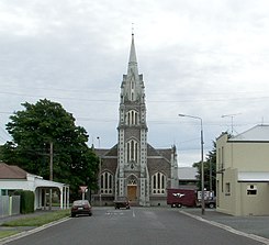
 Lawson's impressive church dominates the old road to Fairfax (Tokoiti) |
||
Milton is a place in the Clutha District of the Otago regionon the South Island of New Zealand .
Origin of name
Milton used to be called " Mill Town " because a flour mill was built in the village during the founding phase. The name later became the current name of the place.
geography
Milton is located around 50 km southwest of Dunedin and around 22 km northeast of Balclutha in the plain of the Tokomairiro River , which flows by west and south of the city.
history
The first settler in the Milton area was James Elder Brown with his father and Peter McGill . They bought land in the area in 1856 and McGill , with the help of Brown, built a flour mill that eventually marked the origin of the place.
Milton's early history was heavily influenced by the Otago Gold Rush (1861–1863), which was triggered by gold prospector Thomas Gabriel Read at Gabriel's Gully near Lawrence . Milton was on the main line between the gold fields and the city of Dunedin , which was the center of the gold trade at the time. Milton experienced such a strong population growth and was granted city status in 1866. In 1897 the city experienced a further boom with the settlement of a wool processing factory.
The seat of the parish was originally Fairfax , a settlement at the foot of the hills in the southeast of the city. When the connection to the gold fields in the interior of the country grew in importance, and with it the desire to use the city as a stopover, it spread to the plain by the river. A Gothic church, the Tokomairiro Presbyterian Church belonging to the Presbyterian Church of Aotearoa New Zealand , was built at the time under the direction of the architect Robert Lawson . The church is still the symbol of the city and can be seen from the Tokomairiro Plains for several kilometers. It was at the end of the main road that connected Fairfax to the main line between Dunedin and the Goldfields.
Milton's importance in communications in the early years of European settlement in New Zealand is underscored by the fact that in February 1878 the city was one of the first two centers connected by long-distance telephone lines, Milton and Dunedin . It was not until the early 20th century that Milton was overtaken in the region by the now considerably larger town of Balclutha .
population
In the 2013 census, the town had 1926 inhabitants, 2.1% more than in the 2006 census.
economy
Milton serves as a service center for the surrounding agriculture, with forestry becoming increasingly important. In the city are Wilson's Transport , one of the largest regional carrier and Calder Stewart one of the biggest metal processing companies, Otago s, settled.
The construction of a prison in Milburn , about 2 km northeast of Milton , sparked controversy among the population when the project was presented to the public.
Infrastructure
Road traffic
The New Zealand State Highway 1 runs through Milton and connects the town with the next two largest cities, Dunedin and Balclutha . South of the village, the New Zealand State Highway 8 branches off from State Highway 1 to the northeast.
Rail transport
Milton was connected to the national rail network in the early 1870s when the Main South Line was built through the city. In 1907, the city became a stopping point when an extension of the Roxburgh Branch was moved from the original hub in nearby Clarksville parallel to the main line to Milton to facilitate operations.
This route was taken out of service in 1960 and the connection point moved back to Clarksville . The Main South Line remained, but since the Southerner passenger train was closed in 2002, only goods have been transported on the route.
Education
Milton played an important role in the education system of Otago's early development . The Tokomairiro School , today divided into the Milton Primary School and Tokomairiro High School , was founded in 1856, eight years after the founding of the Province of Otago , and was for many years one of the leading schools in the province.
The kink
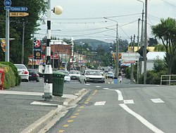
There is an urban planning curiosity in Milton : The town's main street, Union Street , is offset by a whole street width in an east-west direction. The reason is disputed. A common variant, which has not been officially confirmed, is that the road was measured by two surveyors who came from the north and south and who, as seen by themselves, laid the road to the right of the survey line. Another common explanation is that the kink was around a large tree that once stood there. However, this does not explain why, of all places, a single tree in a sawmill town should have been protected and why the road after the tree does not follow its original course again.
Personalities
- Frank Oliver (1948–2014), rugby player for the All Blacks
- Daryl Tuffey , cricket player
- Ken Bloxham , All Blacks rugby player
literature
- Helga Neubauer: Milton . In: The New Zealand Book . 1st edition. NZ Visitor Publications , Nelson 2003, ISBN 1-877339-00-8 , pp. 804 f .
- Alan Gunn : Milton, Otago . John McIndoe , Dunedin 1977 (English).
Web links
Individual evidence
- ↑ a b 2013 Census QuickStats about a place: Milton . Statistics New Zealand , accessed July 17, 2016 .
- ↑ a b c Neubauer: Milton . In: The New Zealand Book . 2003, p. 805 .
- ↑ Topo250 maps . Land Information New Zealand , accessed August 9, 2017 .

