Mossburn
| Mossburn | ||
| Geographical location | ||
|
|
||
| Coordinates | 45 ° 40 ′ S , 168 ° 14 ′ E | |
| Region ISO | NZ-STL | |
| Country |
|
|
| region | Southland | |
| District | Southland District | |
| Ward | Five Rivers Ward | |
| Residents | 210 (2013) | |
| height | 289 m | |
| Post Code | 9792 | |
| Telephone code | +64 (0) 3 | |
| UN / LOCODE | NZ MOS | |
| Photography of the place | ||
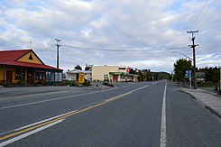
 The State Highway 94 in Moss Burn |
||
Mossburn is a village in the Southland District of the Southland regionon the South Island of New Zealand .
geography
The village is located around 50 km southeast of Te Anau and around 73 km northwest of Gore in the wide plain of the Oreti River . The next larger town is Lumsden , around 17 km south-east.
population
In the 2013 census, the village had 210 inhabitants, 11.4% less than in the 2006 census.
economy
The economy of the place is characterized by agriculture, especially cattle breeding, deer breeding and sheep farming. Because of the large number of deer farms, Mossburn sees itself as the "deer capital" of New Zealand. The dairy industry has gained in importance in recent years through the transformation of sheep holdings and mixed farms.
Infrastructure
Road traffic
The New Zealand State Highway 94 , which connects the place with Te Anau and Gore , runs through Mossburn . The New Zealand State Highway 97 begins in Mossburn and connects to the New Zealand State Highway 6 to Five Rivers . It is part of the Southern Scenic Route .
Rail transport
The Mossburn Branch was a rail link between Lumsden and the Kingston Branch . Construction began in 1879. Mossburn was attached in 1887. In 1982 the line was discontinued and the line dismantled. During the construction of the Manapouri hydropower plant from 1964 to 1971, the route was heavily frequented, as Mossburn was the closest to the project location for material transport.
Power supply
At the end of 2006 / beginning of 2007, a wind farm with 29 turbines of 2 MW each was built on White Hill , about 12 km southwest . At full capacity, it can supply 30,000 households with electricity. The wind farm was opened on June 8, 2007 by Prime Minister Helen Clark .
Web links
Individual evidence
- ↑ a b 2013 Census QuickStats about a place: Mossburn . Statistics New Zealand , accessed August 10, 2017 .
- ↑ a b Topo250 maps . Land Information New Zealand , accessed August 10, 2017 .
