
Slope Point
| Slope Point | ||
 Sign at the slope point with information on distances to the equator and south pole |
||
| Geographical location | ||
|
||
| Coordinates | 46 ° 41 ′ S , 169 ° 0 ′ E | |
| location | Southland District , Southland , South Island | |
| Waters | southern pacific ocean | |
| length | 300 m | |
| width | 110 m | |
| height | 26 m | |
| lighthouse | beacon | |
| particularities | Southernmost point of the South Island of New Zealand | |

The Slope Point is a cape in Southland District of Region Southland on the South Island of New Zealand . The cape represents the southernmost point of the South Island.
Origin of name
The English term “ slope ” stands for slope, slope or embankment, among other things. This is probably why this point on the coast, like a slope or embankment, was given the name " Slope Point " .
geography
The Slope Point is located around 55 km southeast of Invercargill and around 63 km south of Gore on the southern coast of the South Island. Ruapuke Island , located in Foveaux Strait , is about 36 km west-southwest.
The cape can be reached via Slope Point Road , which branches off 5.5 kilometers north of Tokanui Haldane Road and which has its origin in the small village of Tokanui . From the parking lot on Slope Point Road , an approx. 800 m long and 20 minute walk leads to the beacon and the cape.
Slope Point as a farm location
Slightly north of the cape is the Slope Point farm town , which consists of a few farms.
tourism
Tourists who travel the Southland region and follow the Southern Scenic Route are mostly drawn to the Cape of Slope Point to have a photo of the cape and the feeling of having been at the southernmost point of the two main islands of New Zealand.
Photo gallery
- Slope Point

Beacon on the cape

Information sign with cape in the background
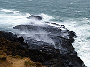
Rocks protruding into the sea at Slope Point
.jpg)


literature
- Helga Neubauer: Slope Point . In: The New Zealand Book . 1st edition. NZ Visitor Publications , Nelson 2003, ISBN 1-877339-00-8 .