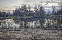
Rakne eyes
The Raknehaugen not far from the church of Hovin in Ullensaker in Viken is the largest burial mound in Norway and one of the largest in Northern Europe .
description
The diameter of the mound was around 95 meters while the reconstructed mound measures around 77 meters. The total height is about 19 meters. It belongs to a unique group of large grave monuments from the Iron Age . In addition to being the largest single monument in Norwegian prehistory, it has an important position within Nordic archeology. The aim of the monumental construction was a show of power. Today the hill is on the Ljøgodt farm, when it was built it was very likely part of Hovin Grunn. The name of the farm comes from Ljóðgata, which means “street where many people walk”.
According to a legend, the hill is the tomb of a king who was buried between two white horses.
The digs
1869-70
1869–70, the law student and amateur archaeologist Anders Lorange examined the hill for the first time. Lorange dug a trench from the east side, but had to give up because of the earth sliding down. He then tried to dig a tunnel towards the center of the hill. This attempt also had to be abandoned. Lastly, he dug from the top of the hill to the ground without finding a grave.
1939-40
In 1939 the archaeologist Sigurd Grieg began an investigation of the hill. With a large group of unemployed people, he dug two wide trenches (and two narrow ones) from the southeast and southwest (due to current world events they were called the "Eastern" and "Western Front"). He found some stoves and charcoal, but no grave. The trenches were dug to the ground and revealed features of the structure. The hill was built on a natural hill about six meters high. Thick layers of clay, sand and earth were then applied in a conical shape. Originally it was estimated that a total of 80,000 m³ of material was moved, later this estimate was reduced to around 26,000 m³. According to Grieg's theory, the hill was a cenotaph for a dead chief or other important figure.
1993
In 1993, archaeologist Dagfinn Skre was given the opportunity to take a closer look at the material from Grieg's excavation when he was doing smaller digs. He examined one of Grieg's smaller trenches in the northwest part of the hill. A critical review of the Grieg excavation is now available. Examination of material from fireplaces and cooking pits revealed fragments of burned bones, some of them from humans. Skre concludes that the mound was a cremation grave with no additions and not a cenotaph.
The wood in the mound was radiologically dated to AD 552. This dating shows that the trees were felled between AD 533 and 551. The tree rings show that summer 536 (about 16 years earlier) must have been a particularly bad growing season. The construction of the hill must have required a large number of workers, between 450 and 600, according to Skres, an enormous number for Romerike's population at the time .
See also
literature
- Bente Magnus: Raknehaugen. In: Reallexikon der Germanischen Altertumskunde (RGA). 2nd Edition. Volume 24, Walter de Gruyter, Berlin / New York 2003, ISBN 3-11-017575-4 , p. 121 ( chargeable via GAO , De Gruyter Online).
- Joakim Goldhahn: Om döda och efterlevande med exempel från Bredrör, Skelhøj, Sagaholm och Mjeltehaugen. In: Randi Barndon, Sonja M. Innselset, Kari K. Kristoffersen, Trond K. Lødøen (eds.): Samfunn, symboler og identitet. Festskrift til Gro Mandt på 70-årsdagen (= Universitetet i Bergen arkeologiske skrifter. Nordisk. 3). Universitet i Bergen, Bergen 2006, ISBN 82-90273-81-9 , pp. 283-303 ( full text, online PDF; free of charge, 22 pages, 771.17 KB).
Web links
Coordinates: 60 ° 8 ′ 48.7 ″ N , 11 ° 8 ′ 14.2 ″ E

