Rakshastal
|
Rakshastal Rakshas Valley, La'nga Co |
||
|---|---|---|

|
||
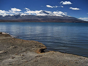
| View across Lake Rakshastal to the south to Gurla Mandhata (2006) | ||
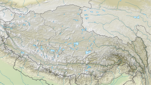
| Geographical location | Circle Purang in the administrative district of Ngari , Tibet Autonomous Region ( China ) | |
| Tributaries | at times from Manasarovar | |
| Drain | Satluj | |
| Data | ||
| Coordinates | 30 ° 42 ' N , 81 ° 14' E | |
|
|
||
| Altitude above sea level | 4572 m | |
| surface | 258 km² | |
| length | 28.6 km | |
| width | 18.9 km | |

|
||
| Satellite image of the two lakes Rakshastal (left) and Manasarovar (right) with Mount Kailash in the background | ||
Rakshastal (or Rakshas Tal ; Tibetan : La'nga Co , ལག་ངར་ མཚོ , transcription after Wylie : lag ngar mtsho ; Chinese 拉昂 错 , Pinyin Lā'áng Cuò ) is a lake in Tibet Autonomous Region , China, west of the lake Manasarovar and south of Mount Kailash . The river Satluj has its source at the northwest corner of the Rakshastal.
geography
Originally the Rakshastal was connected to the Manasarovar to form a lake and was separated from it by geological movements. Between the two lakes there is still a natural connection, called Ganga Chhu , in which water only flows from Manasarovar to the Rakshastal about 15 m below when the snow is melting. Then the Manasarovar is considered the origin of the Satluj. The lake covers an area of 259 km² and is 4572 m above sea level. The lake area shrank by 3 km² in the 10 years up to 2009. One of the causes is the increasing drought in the region, which in 2003 received just over 100 millimeters of precipitation.
In its salty water, which is in contrast to the fresh water of the Manasarovar, no aquatic plants or fish live and it is considered poisonous by the residents of the area. Despite the lack of grass in the vicinity of the lake, its white pebble beaches, the surrounding hills and the dark red colored islands offer an impressive contrast to the deep blue lake water.
Religious meaning
Despite its proximity to Manasarovar on the western side of the road to Burang , the Rakshastal does not share the legends of worship that surround its eastern neighbor. In Buddhism the lake is a contrast to the god-made lake Manasarovar. Manasarovar, round in shape like the sun, and the crescent-shaped Rakshastal are seen as opposites of light and darkness.
According to Hindu mythology , the lake was created by the ten-headed demon king Ravana to gain supernatural powers from the divine Shiva , who was enthroned on Mount Kailash, through an act of devotion and meditation . On the shores of a special island in the lake, he offered one of his ten heads every day as a sacrifice to please Shiva. Finally, on the tenth day, Shiva was so touched by Ravana's devotion that he granted him supernatural powers. That is why it is also called "demon lake".
Web links
literature
- Kailash Sacred Landscape Conservation Initiative. Feasibility Assessment Report of China. (PDF) Institute of Geographic Sciences and Natural Resources Research, Chinese Academy of Sciences, June 12, 2010, accessed April 24, 2011 .
Individual evidence
- ↑ Cf. Kailash Sacred Landscape Conservation Initiative, p. 31, Figure 18., the altitude data vary and reach up to 4752 m; Google Earth shows 4575 m.
- ↑ See Kailash Sacred Landscape Conservation Initiative, p. 8
- ↑ Geologic Map of the Mt. Kailas-Gurla Mandhata Area, southwest Tibet (PDF (821 kB)) easd.geosc.uh.edu.
- ↑ See Kailash Sacred Landscape Conservation Initiative, p. 41
- ↑ See Kailash Sacred Landscape Conservation Initiative, p. 38, Figure 23.
