Gurla Mandhata
| Gurla Mandhata - Naimona'nyi | ||
|---|---|---|
|
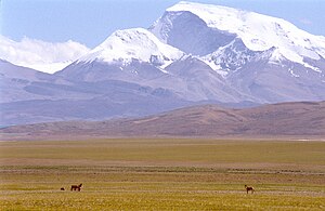
Gurla Mandhata from the north; Tibetan wild ass in the foreground |
||
| height | 7694 m | |
| location | Circle Purang in the administrative district of Ngari in Tibet ( China ) | |
| Mountains | Nalakankar Himal ( Himalaya ) | |
| Dominance | 127.53 km → Nanda Devi | |
| Notch height | 2788 m ↓ ( 4906 m ) | |
| Coordinates | 30 ° 26 '18 " N , 81 ° 17' 46" E | |
|
|
||
| First ascent | May 26th, 1985 by Cirenuoji, Jiabu, Jin Junxi, K. Matsubayashi, Song Zhiyu, K. Suita, Y. Suita, T. Wada | |
| Normal way | Western flank (glaciated) | |
| Tibetan name |
|---|
|
Tibetan script :
གནས་ མོ་ སྣ་ གཉིས་ །
|
|
Wylie transliteration : gnas mo sna gnyis
|
|
Official transcription of the PRCh : Naimona'nyi
|
|
THDL transcription : Nemona Nyi
|
| Chinese name |
|
Simplified :
纳 木 那 尼 (郎 木 那里 、 那 玛 郎 尼 峰 、 瓜 拉曼达塔)
|
|
Pinyin : Nàmùnàní (Lángmùnàlǐ, Nàmǎlángní Fēng, Guālāmàndátǎ)
|
The Naimona'nyi (also: Gurla Mandhata ) is located in the northeast of the seat of the district government of Burang in the administrative district of Ngari , in the southwest of the Tibet Autonomous Region of the People's Republic of China . It is the highest peak of the Nalakankar Himal , a small, western part of the Himalayas .
geography
The mountain, sloping to the west like a desk, is near the northwest corner of Nepal . With its height of 7694 m , it is the thirty-fourth highest mountain in the world. Its location within the Tibetan plateau is unusual (most mountains of similar height - except for Shishapangma , the fourteenth highest mountain in the world - are closer to the edge or outside the plateau) and relatively far from other mountains higher than 7,500 meters. It is located near the Manasarovar and Rakshastal Lakes and the sacred Kailash Mountain .
In 2003 the Gurlagletscher had an extension of 77 km², whereby its area has decreased by more than 7 km² since 1976. According to Chinese measurements at an altitude of 6100 m , the glacier is the highest glacier where annual ice loss has been documented. The Humla Karnali , the right source river of the Karnali ( Ghaghara ), which flows into the Ganges after more than 900 kilometers, has its source at the glacier .
Ascent history
In 1905 TG Longstaff, who was accompanied by two mountain guides and six porters, tried to climb the Gurla Mandhata. They had to turn back high on the mountain after being caught in an avalanche and encountering further difficulties. That was a great achievement for the time, especially for such a small group; at that time no summit had been climbed more than 7000 meters and the height of Longstaff deserved an altitude record.
Another attempt was made by Herbert Tichy , who with a companion on 16. – 21. May 1935 on the route of Longstaff, but had to turn back at 7200 meters. An intended second attempt on the new route was not made because the first ascent had been observed and Tichy, who was illegally disguised as a Kailash pilgrim in Tibet, feared problems with the authorities in Taklakot .
The first ascent of the summit was achieved in May 1985 by a Sino-Japanese rope team.
Since then there have been six successful and two unsuccessful attempts at ascent.
In 1997 Quinn Simons, Soren Peters and their guide Charlie Fowler made an attempt to reach the summit via the still unclimbed north face. Due to storms and other difficulties, the rope team had to turn back high on the mountain. During their descent, Fowler was slightly injured in a fall, while Simons and Peters suffered frostbite on their extremities.
The normal route leads over the western flanks of the mountain, on the Chaglung'mlungha glacier to the summit plateau. Most rope teams approach the mountain in off-road vehicles from Lhasa (Tibet) or from Kathmandu (Nepal). However, an alternative approach begins in the small mountain village of Simikot in the remote Humla district of western Nepal and then follows the Karnali River northwards to the village of Sher (Tibet). Then jeeps drive the climbers north through Burang ("Taklakot") to the base camp.
literature
- Herbert Tichy : To the holiest mountain in the world. 6th edition. Seidel, Vienna 1956, pp. 121-133
Web links
- A list of famous mountains of Asia (English)
- Data from surveys (English)
- Historical photo of Gurla Mandhata with Mount Kailas taken from the Lipu Pass. (English)
- Gurla Mandhata on Peakbagger.com (English)
- Gurla Mandhata at Peakware (English)
- Gurla Mandhata at summitpost.org
Individual evidence
- ↑ 国家 测绘 局 地名 研究所 (Ed.): ༄ ༅ ༎ བོད་ ལྗོངས་ ས་ མིང ༎ / «西藏 地名». Běijīng: ཀྲུང་ གོའ ི་ བོད་ རིག་པ་ དཔེ་ སྐྲུན་ ཁང ། / 中国 藏 学 出版社, 1995, p. 332.
- ↑ See Kailash Sacred Landscape Conservation Initiative. Feasibility Assessment Report of China, page 43. (PDF) Institute of Geographic Sciences and Natural Resources Research, Chinese Academy of Sciences, June 12, 2010, accessed April 24, 2011 .
- ↑ a b Asia, China, Naimona'nyi (Gurla Mandhata) . American Alpine Journal 1986, vol. 28, p. 302.
- ↑ Tichy: To the holiest mountain in the world. 6th edition Vienna 1956, p. 132
- ↑ The Himalayan Index of the Alpine Club lists five climbs and two failed attempts until 2001. The American Alpine Journal recorded neither successful nor unsuccessful attempts between 2002 and 2005. The expedition report of the first American ascent of Gurla Mandhata records an ascent in 2006.
- ↑ American Alpine Journal 1999, pp. 211-213. ( Page no longer available , search in web archives ) Info: The link was automatically marked as defective. Please check the link according to the instructions and then remove this notice.

