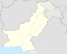
Ranicot
Coordinates: 25 ° 52 '59 " N , 67 ° 55' 56" E
The fortress of Ranikot (also Rannikot) is a huge defensive structure in the south of today's Pakistan , in the province of Sindh . It is located about 75 kilometers north-northwest of Hyderabad .
According to Pakistani scientists, the complex, which is largely unexplored in its history, is the largest existing fortress in the world. In December 1993, the Pakistani government had the fortress entered in the tentative list of sites that are potentially suitable for UNESCO World Heritage status .
location
Ranikot Fortress is located in the Kirthar Mountains , about 35 kilometers west of the Indus . On the northeastern edge of the fortress lie the already explored ruins of the prehistoric city of Amri - eponymous place of a 3000 BC. Flourishing high culture on the Indus.
The builders of the fortress cleverly used the natural features of the canyon-like river valley for the design of the entire complex. The western flank of the fortress is formed by the Karo Takkar (Black Mountain) mountain range, lined with steep cliffs . The Lundi Hills run about six kilometers east of the river and form the eastern boundary of the fortress. The up to 100 meter high rock walls were considered insurmountable. The desolate surroundings of the fortress made it easier to control the huge complex, which made their own water supply all the more important for the residents and defenders. In addition to some natural springs, the Sindhu River and some smaller tributaries led drinking water into the interior of the fortress, and cisterns and ponds could also be found. Several steep mountains tower up inside the fortress, they support the two inner fortifications - the mountain fortress Meeri ( Lage ) and the mountain fortress Shergarh ( Lage ) .
Construction details
The overall reconstructed structure of the fortress is impressive because of its numbers: the enclosed basin is secured by sections of wall that are eight kilometers in length and six meters on average. The entire defense system was 29 kilometers in circumference. The structure of the wall is reminiscent of the Great Wall of China . On the inside of the wall, which is up to five meters thick, runs a battlement with stairs on the steep slopes, a total of 85 round towers and bastions have been recorded so far.
Only two gates enabled access to the fortress, these were secured by gate castles. The eastern gate is called Sanngate , the northeast gate is called Amrigate , and in front of its gates are the ruins of the city of the same name. The two rivers were also secured by barriers. Two more gates or breaches in the wall, which were only recognizable from the inside, could have been prepared as a precaution for a relief attack. One gate was named Mirigate and the second Sher Gash Fort . The two mountain fortresses, which could serve as the last retreats for the defenders and were interpreted as residential and palace complexes for the ruling dynasty and as a prison, were also located within the overall complex.
So far, only a few remains of crew quarters, storage facilities and workshops within the fortress have been uncovered. A place within the fortress used as a burial place is called the Roman cemetery by the local population . Myths and legends also tell of fairies who gathered at certain sources within the fortress for ritual acts - possibly references to old places of worship.
Younger story
The fortress served as the seat of the local Talpur dynasty until the middle of the 19th century. Faced with the constant threat to their country from rival princes and the British, the Talpurs invested 1.2 million rupees to strengthen and repair the fortress in the middle of the 19th century. The British ambassadors at the court of the Talpur prince were skillful enough to explain their hopeless situation to the royal family. These fortifications were ineffective as protection against the modern artillery of the British, so the fortress was handed over without a fight and was later forgotten. Farmers now also penetrated the valley and were allowed to build settlements and fields at the foot of the mountain fortresses.
A scientific investigation did not begin until the 1950s, but it initially focused on the archaeological evidence of the Amri culture. After Pakistan's independence, this essentially pre-Islamic fortress went unnoticed.
Impressions
Monument protection
Parts of the fortress walls and the two mountain fortresses have been restored for tourist visitors. The facility is being systematically researched and rehabilitation projects are being implemented in sections. The Pakistani government is hoping that the designation as a world cultural heritage will attract further tourist attention, and the Kirthar National Park also borders the fortress to the south .
Trivia
- Geology: The area of the fortress is rich in fossils and geologically significant, it gave the Ranikot formation its name.
- Postage stamp: In 1986 the Pakistani postal administration issued a 90- Paise stamp with a view of the fortress as a motif in circulation.
Individual evidence
- ↑ a b c d e Salman Rashid: Footloose: Rannikot. The Daily Times June 6, 2008, archived from the original April 13, 2012 ; accessed on April 13, 2011 (English).
- ↑ Rani Kot Fort, Dadu. UNESCO, 2011, p. 1284 , accessed on April 13, 2011 (English, database entry).
- ^ Isham H. Nadiem: Forts of Pakistan . Al-Faisal Publ., 2004.
- ^ A b Goth Haidar Khan: Ranikot Fort: Vernacular Architecture. (No longer available online.) 2011, archived from the original on February 29, 2012 ; accessed on April 13, 2011 (English, specifications). Info: The archive link was inserted automatically and has not yet been checked. Please check the original and archive link according to the instructions and then remove this notice.


