Redingsdorfer See
| Redingsdorfer See | ||
|---|---|---|

|
||
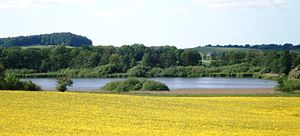
| The Redingsdorfer See (from the southeast) | ||
| Geographical location | Ostholstein district | |
| Drain | Steinbach to Neustädter inland water | |
| Location close to the shore | Bujendorf | |
| Data | ||
| Coordinates | 54 ° 6 '33 " N , 10 ° 42' 52" E | |
|
|
||
| surface | 12.6 ha | |
| length | 0.6 km | |
| volume | 210,000 m³ | |
| scope | 1.4 km | |
| Maximum depth | 4.5 m | |
| Middle deep | 1.67 m | |
The Redingsdorfer See is located north of Bujendorf in the Ostholstein district in Schleswig-Holstein . It is located in Holstein Switzerland , surrounded by a hilly moraine landscape .
The lake has a round basic shape with a large bay in the southeast with a maximum length of approx. 600 m (in NW / SE direction). It has a size of approx. 13 hectares and is very shallow with a depth of usually much less than a meter and therefore threatened with silting up.
Around 1938, the lake's water level was lowered, reducing its area and depth. In 1988 the lake was redeveloped - u. a. by dredging mud. After completion of the renovation work, the Redingsdorfer See is two meters deep.
The Redingsdorfer See drains over the Steinbach into the Neustädter inland water .
swell
- The data on the lake: Redingsdorfer See & explanations of the landscape framework plan for planning area II - Ostholstein district and the Hanseatic city of Lübeck
- To Steinbach : [1] (PDF; 3.3 MB)
