Rego da Murta
| Rego da Murta | ||||||
|---|---|---|---|---|---|---|
|
||||||
| Basic data | ||||||
| Coordinates : | 39 ° 47 ′ N , 8 ° 21 ′ W | |||||
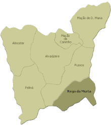
Rego da Murta is a place and a former municipality in Portugal .
history
Rego da Murta has been an independent municipality since at least 1712.
With the territorial reform in Portugal in 2013, the municipalities of Rego da Murta and Pussos were merged to form the new municipality of Pussos São Pedro .
administration
Rego da Murta was the seat of a municipality of the same name ( Freguesia ) in the district ( Concelho ) of Alvaiázere in the Leiria district . 849 inhabitants live in the former municipality on an area of 16.63 km² (as of June 30, 2011)
The following localities are in the area of the former municipality of Rego da Murta:
|
|
|
|
As part of the administrative reorganization in Portugal on September 29, 2013, the municipalities of Rego da Murta and Pussos were merged to form the new municipality of Pussos São Pedro .
Web links
Individual evidence
- ^ Entry of the parish church of Rego da Murta in the Portuguese list of monuments SIPA (under Cronologia ), accessed on September 16, 2016
- ^ Publication of the administrative reorganization in the Diário da República gazette of January 28, 2013, accessed on October 1, 2014.


