
Reichertshauserer valley

The Reichertshauserer Tal is an approximately eight kilometer long, predominantly forested cut in the Bavarian foothills of the Alps between Föggenbeuern near Dietramszell and Egling , whose name has apparently been forgotten over time.
On the land survey map of the Kingdom of Bavaria from 1877 the dry valley is referred to as Reichertshauserer Thal . It was named after the town of Reichertshausen , which now belongs to Egling . Today street names Im Thal and the single farm Thalweber still point to the forgotten name.
The cut in the terrain begins south of Föggenbeuern and meanders six kilometers almost exactly north, only to bend west near Fraßhausen and Wörschhausen. From here on, the three Thanninger ponds for fish farming were created by the abbot of Schäftlarn monastery at the beginning of the 18th century . These are fed from the Moosbach , which rises in the Reichertshauserer valley a few hundred meters above the first pond in the Frauenholz area. The valley ends in Egling .

Chapel of St. Koloman near Reichertshausen
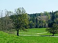
View from the chapel over the valley

"Talholz" near Hölching


Coordinates: 47 ° 53 ′ 55 " N , 11 ° 33 ′ 45" E