Relief land
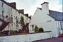
A row of buildings along Main Street in the Scottish town of Inveraray is called Relief Land . The buildings are located directly south of Inveraray Parish Church and are therefore directly on the A83 , which connects the south of the region to the Kintyre Peninsula and the Central Belt . In 1966 Relief Land was included in the Scottish List of Monuments in the highest category A as an ensemble .
description
Relief Land consists of five identical single houses that were built in a closed construction along the street. They were completed in 1779 and have the characteristics of the simple Georgian architecture . The buildings are three-story and equipped with lattice windows along the front, which symmetrically surround central entrance doors. They end with slate-covered gable roofs . All facades are plastered using the traditional Harling technique. Along the back of each of the houses has an exterior staircase that is more recent. The buildings are used as residential buildings.
Individual evidence
- ↑ a b Listed Building - Entry . In: Historic Scotland .
Web links
- Entry on Relief Land in Canmore, Historic Environment Scotland's database
Coordinates: 56 ° 13 '46.7 " N , 5 ° 4' 24.9" W.

