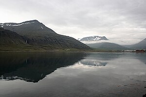
Reyðarfjörður (fjord)
| Reyðarfjörður | ||
|---|---|---|
|
Reyðarfjörður |
||
| Waters | Norðfjarðarflói, Atlantic Ocean | |
| Land mass | Iceland | |
| Geographical location | 65 ° 2 ′ N , 14 ° 14 ′ W | |
|
|
||
| width | 7 km | |
| length | 30 km | |
| Tributaries | Sléttuá | |
The Reyðarfjörður is the longest fjord of the eastern fjords of Iceland . Inside the fjord on the north bank lies the town of the same name , which was originally called Búðareyri.
The fjord extends 30 km into the country and is up to 7 km wide. The area is located in the municipality of Fjarðabyggð . Inside the Eskifjörður branches off to the north .
At the southwestern tip, the ring road from Egilsstaðir reaches the fjord and then disappears into Fáskrúðsfjarðargöng . The further south bank is accessed from Vattarnesvegur ![]() . On the north bank, the Norðfjarðarvegur leads
. On the north bank, the Norðfjarðarvegur leads ![]() to Eskifjörður . From the place the Helgustaðavegur
to Eskifjörður . From the place the Helgustaðavegur ![]() and the Vöðlavíkurvegur
and the Vöðlavíkurvegur ![]() continue along the north bank.
continue along the north bank.

