Reykjanesviti
| Reykjanesviti | ||
|---|---|---|
| Place: | Reykjanesskagi , Iceland | |
| Location: | Suðurnes , Iceland | |
| Geographical location: | 63 ° 48 ′ 56.2 " N , 22 ° 42 ′ 15" W | |
| Fire carrier height : | 31 m | |
| Fire height : | 69 m | |
|
|
||
| Identifier : | Fl (2) W.30s | |
| Scope knows: | 22 nm (40.7 km ) | |
| Operating time: | since 1908 | |
| International ordinal number: | L 4466 | |
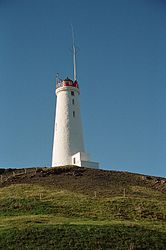
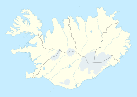
Reykjanesviti (Eng. Reykjanes Lighthouse ) is a lighthouse on the southwest tip of Iceland on the Reykjanesskagi peninsula . The predecessor of today's structure was the island's first lighthouse.
The tower was first erected on Mount Valahnúkur and commissioned on December 1, 1878. It was octagonal and six feet high. The tower was badly damaged in an earthquake on October 28, 1887. In 1905 it was only 10 m away from the edge of the mountain, which is why a new tower was built further inland on Bæjarfell in 1907/08 according to plans by the Danish architect Frederik Kiørboe (1878–1952). The old tower was blown up on April 16, 1908. The current tower has been in operation since 1908, a round concrete tower with a traditional appearance. It has a height of 31 meters, the fire carrier is at a height of 69 meters above sea level. The tower is white, only the light room is painted red.
The characteristic sign of the tower is a double flashing light every thirty seconds. On the roof there is a self-radiating transmitter mast, insulated from earth, for a DGPS transmitter that transmits on the frequency 293.5 kHz.
Web links
Individual evidence
- ↑ Official information from the Authority for Marine Management ( Memento of the original dated August 8, 2014 in the Internet Archive ) Info: The archive link was inserted automatically and has not yet been checked. Please check the original and archive link according to the instructions and then remove this notice. , accessed March 29, 2017 (Icelandic)
- ↑ Information board at the foot of Valahnúkur, seen on March 27, 2017.

