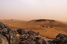
Guelb er Richat

Guelb er Richat ( Arabic قلب الريشات, DMG Qalb ar-Rīšāt ), German also Richat structure , circumscribed with the eye of Africa , bull's eye or eye of the Sahara , is a ring-shaped, crater-like geological formation in Mauritania in the west of the Sahara .
Guelb means "island mountain" in the flat Sahara. The ring mounds are located in the Adrar province about 30 kilometers northeast of the small town of Ouadane . They have a diameter of 45 kilometers. The concentric ramparts are only a few meters high and consist of sedimentary rock .
Geological origin
The structure was originally interpreted as a meteorite crater , but this is not generally supported due to the lack of impact rocks . The Sahara researcher Théodore Monod published a paper in 1954 in which he described five such craters in Mauritania and in four of them, including the Richat, supported the common view that it could be a volcanic explosion on earth; he only wanted the impact on the fifth of a meteorite. In 1969 Robert S. Dietz discovered evidence of a meteorite impact . The origin of this circular structure has not been fully clarified; a more recent study assumes that the structure was created by the erosion of a dome structure . This, in turn, was arched up by magmatic intrusions, and hydrothermal fluids penetrated through the weak zones that resulted, which caused karstification and silicification of the material.
Since the structure can be seen particularly conspicuously from space, it was used by astronauts as a landmark for orientation during shuttle missions .
Web links
- Article in SPIEGEL ONLINE
- NASA Earth Observatory page (English)
- Earth's Richat Structure - Astronomy Picture of the Day of October 28, 2002 (English).
- Annual Meteoritical Society Meeting (2001) (PDF, English; 83 kB)
- ens.ch/ photo of the center. March 2009
Individual evidence
- ^ Théodore Monod, Souvenirs sahariens d'un vieux géologue amateur, COFRHIGEO 1986 , website of the Annales des Mines
- ^ UB Marvin: Théodore André Monod and the lost 'Fer de Dieu' meteorite of Chinguetti, Mauritania. In: Patrick N. Wyse Jackson (Ed.): Four Centuries of Geological Travel: The Search for Knowledge on Foot, Bicycle, Sledge and Camel. (Geological Society Special Publication) Geological Society, 2007, p. 201 ( at google books )
- ^ Matton, G .; Jebrak, M .; Lee, J .: Resolving the Richat enigma: Doming and hydrothermalkarstification above an alkaline complex
Coordinates: 21 ° 8 ′ N , 11 ° 24 ′ W


