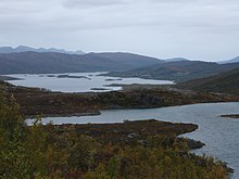
Ringvassøy
| Ringvassøy | ||
|---|---|---|
| Waters | Atlantic | |
| Geographical location | 69 ° 55 ' N , 19 ° 15' E | |
|
|
||
| length | 34 km | |
| width | 37 km | |
| surface | 656 km² | |
| Highest elevation | Soltindan 1051 m |
|
| Residents | 457 <1 inh / km² |
|
| main place | Hansnes | |
| Location of Ringvassøy | ||
Ringvassøy ( North Sami : Ráneš , Norsk bokmål: Ringvassøya ) is the sixth largest island in Norway .
geography
Ringvassøy is surrounded by other islands: Kvaløy in the south; Reinøy and Karlsøy in the east; Vannøy , Helgøy and Nordkvaløy in the north and Rebbenesøy in the northwest. The highest point is the Soltindan with 1051 m. On Ringvassøy, Skogsfjordvatn is also Norway's largest lake on an island.
Political structure
Ringvassøy belongs to the province ( Fylke ) Troms og Finnmark in Northern Norway . Its northern part belongs to the municipality of Karlsøy , its southern part to the city of Tromsø . The capital of the island is Hansnes with 457 inhabitants , which has also been the administrative center of Karlsøy municipality since 1970. Hansnes is connected to the provincial capital Tromsø via the Kvalsund Tunnel and is also the docking port for the ferries to Vannøy, Reinøy and Karlsøy.
Footnotes
- ^ Statistisk sentralbyrå : Urban settlements. Population and area, by municipality. . January 1, 2013.


