Rio Pará
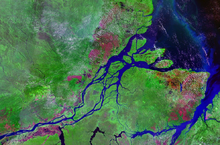
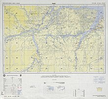
Rio Pará is the name of a narrow, deeply extending sea bay between the Amazon estuary and the estuary of the Rio Tocantins further southeast . Connections with the Amazon estuary exist via tidal channels, some of which are navigable, so-called furos . They also separate the island of Marajó , which forms the north bank of the Rio Pará, from the mainland.
course
The elongated, 4-20 km wide and around 180 km long bay extends inland in a westerly direction from about 49 ° 45 'to about 50 ° 15' west longitude . In the eastern third, the somewhat wider but shorter mouth of the Rio Tocantins branches off to the south, which fills it with its sediments from the south, creating numerous islands. Other rivers flow particularly near the western end of the bay, such as Rio Anapu , Rio Pacajá , Rio Camaraipi and Rio Jacundá (around the height of Breves ). There are also numerous cross-connections to the Amazon estuary in the north , which alternate with the tides . Most of the sediment load ends up in the Rio Pará when the floods of the Amazon find its way through these furos to this bay. In the east, the Rio Pará merges into the Baía de Marajó , which in turn opens into the South Atlantic. Due to the flowing rivers, the water of the bay, increasing inland, is brackish .
The capital of the Brazilian state of Pará , named after the Rio Pará , the seaport Belém , is located on the eastern bank of the common confluence of the Guajará and Moju rivers coming from the east, which opens into the Baía de Marajó.
As part of the Amazon-Belém shipping route, the Rio Pará is sometimes referred to as the Canal de Breves .
Geological situation and formation
The Pará River is located in the area of the earth's surface barely emerging, trending north-northwest trench that extends from the Miocene formed and drained by the Rio Tocantins and was filled with sediments. The current bay seems to have formed only in the recent geological past as a result of leaf movement that has been detectable since the middle of the Holocene . A temporary reshaping of the Rio Pará by a southern branch of the mouth of the Amazon has been considered several times. Today only a small part of the Amazon water reaches the Rio Pará via the Furos . A delta has formed at the confluence with the bay. The rivers Rio Anapu and Rio Pacajá coming from the west face north in their upper reaches and previously flowed via Rio da Laguna towards the mouth of the Amazon. For about 6000 years, their former flat valleys have been covered by the waters of the Baia de Caxiuana and Baia Pacajaí lakes , and their water mainly reaches the water surface of the Rio Pará to the east via former watersheds that have also sunk.
Rivers flowing into the bay
The largest rivers include (from west to east):
- Furo do Tajapuru and Rio de Breves (tidal channels going west to the Amazon estuary)
- Rio Jacundá (from the south)
- Rio Araticu (from the south)
- Rio Tocantins (from the south)
See also
Web links
Individual evidence
- ↑ Dilce de Fátima Rossetti, Márcio M. Valeriano: Applying SRTM topographic data to characterize a Quaternary paleovalley in northern Brazil (PDF; 1.0 MB) . Anais XIII Simposio Brasileiro de Sensoriamento Remoto, Florianopolis, Brasil, 2007, INPE, pp. 2125-2132
- ^ Hermann Behling, Marcondes Lima da Costa: Holocene Environmental Changes from the Rio Curua 'Record in the Caxiuana' Region, Eastern Amazon Basin , Quaternary Research 53, 369-377 Washington 2000
- ^ Kümmerly + Frey Rand McNally: International Atlas . Published by Georg Westermann Verlag ISBN 3-07-508962-1
Coordinates: 1 ° 43 ′ 40 ″ S , 49 ° 10 ′ 30 ″ W


