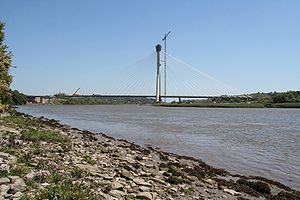
River Suir Bridge
Coordinates: 52 ° 16 ′ 44 " N , 7 ° 9 ′ 4" W.
| River Suir Bridge | ||
|---|---|---|
| use | Road bridge | |
| Convicted | N25 | |
| Crossing of | Suir | |
| place | Waterford in Ireland | |
| construction | Cable-stayed bridge | |
| overall length | 465 m | |
| width | 30.6 m | |
| Longest span | 230 m | |
| Clear height | 14 m | |
| start of building | 2006 | |
| completion | 2009 | |
| location | ||
|
|
||
The River Suir Bridge ( Irish Droichead na Siúire ) spans the River Suir near Waterford in Ireland . Since its completion in 2009, the road bridge has been part of the N25 national road with two lanes in each direction , which bypasses Waterford on a new route. The single-hip cable - stayed bridge has the largest span of a bridge in Ireland at 230 m .
construction
The total of 30.6 m wide and 465 m long structure has five openings with spans of 40 m, 70 m, 90 m, 230 m and 35 m. The deck is a steel composite structure that is supported in the main opening by 38 cables. The suspension cables with a diameter of 25 cm to 40 cm and a maximum length of 225 m are arranged on two levels and anchored in a 112 m high A-pylon made of reinforced concrete . The pylon posts, made with climbing formwork, have a distance of 53 m below and are founded on 94 steel piles. The river was opening in cantilever built, the deck slab with precast reinforced concrete manufactured.
Web links
- www.waterfordcity.ie ( Memento of October 24, 2012 in the Internet Archive )
- http://www.doka.com/doka/de_global/services/presscorner/pages/05544/index.php

