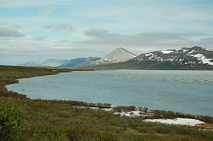
Salmon Lake (Pilgrim River)
| Salmon Lake | ||
|---|---|---|

|
||
| Salmon Lake (June 2006) | ||
| Geographical location | Alaska (USA) | |
| Tributaries | Grand Central River | |
| Drain | Pilgrim River | |
| Data | ||
| Coordinates | 64 ° 54 ′ 28 ″ N , 164 ° 59 ′ 20 ″ W | |
|
|
||
| Altitude above sea level | 135 m | |
| surface | 7.3 km² | |
| length | 6.5 km | |
| width | 1.6 km | |
| Catchment area | 218 km² | |
The Salmon Lake (Engl. For " Salmon -See") is a lake on the Seward Peninsula in western Alaska .
Salmon Lake is located south at the foot of the Kigluaik Mountains , 47 km north-northeast of the city of Nome . Located at an altitude of 135 m , Salmon Lake covers an area of 7.3 km². The 6.5 km long lake is divided into two basins, which are connected by an arm only 150 m wide. The Grand Central River , the main tributary of Salmon Lake, flows into the western end of the lake. The Fox Creek from the north and the Jasper Creek from the south lead midway length of the lake into the lake. Salmon Lake is drained by the Pilgrim River at its eastern end . The Nome – Taylor Highway runs not far from the northern lake shore.
The lake name was reported by the US Geological Survey (USGS) in 1900 . The Eskimo name Nahwazuk with the meaning "salmon" was also noted.
