
Solomon Islands
| Solomon Islands | ||
|---|---|---|
 (the Île du Sel is here referred to as Île Charles ) |
||
| Waters | Indian Ocean | |
| archipelago | Chagos Archipelago | |
| Geographical location | 5 ° 19 ′ S , 72 ° 16 ′ E | |
|
||
| Number of islands | 11 | |
| Main island | Île Boddam | |
| Land area | 3.5 km² | |
| Lagoon area | 36 km² | |
| Residents | uninhabited | |

The Solomon Islands are an atoll that is part of British Indian Ocean Territory . It is located at about 5.3 degrees south latitude in the north of the Chagos Archipelago between the Blenheim Reef and the Peros Banhos atoll .
geography
The Solomon Islands consist of eleven small islands , of which Boddam is the largest with about 2200 × 500 meters, followed by the only slightly smaller Île Anglaise . Both islands are on the western edge of the reef. Around 400 indigenous people ( Chagossians ) lived here until 1965, and the atoll has been uninhabited since they were forced to resettle. Further settlement areas extended over the Fouquet and Takamaka Islands. The total land area covers about 3.5 km².
The Solomon Islands are among the most popular anchorages for yachts passing through. The now uninhabited islands are completely overgrown with coconut palms, making it difficult to discover the remains of the settlements.
The Baie de Salomon leads northwest between the Île Anglaise and the Île de la Passe into the lagoon.
Islands
The individual islands in clockwise order , starting with the northernmost island:
- Ile de la Passe
- Île Mapou
- Île Takamaka (former settlement)
- Île Fouquet (former settlement)
- Ile Sepulture
- Île Jacobin
- Île du Sel
- Île Poule
- Île Boddam (former main settlement)
- Île Diable
- Île Anglaise (former settlement)
- Views
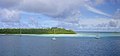
Île Boddam

One of the islands

