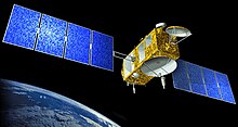
Satellite altimetry


With the help of satellite altimetry , the height of the sea surface and also its ripple is measured. The height of ice surfaces and inland waterways (from a certain minimum size) can also be observed.
A satellite transmits a payload as radar - Altimeter , from this short-wave radio pulses are transmitted vertically downwards reflected at the (marine) surface and receive the signal back to the satellite. If its orbit is known exactly, the sea level can be obtained from the measured transit time of the signal and the geocentric altitude of the satellite.
In addition, other parameters can be calculated from the received signal, e.g. B. the wave height, as this determines the characteristics of the reflected signal, and indirectly the wind strength and ocean currents. Altimetry is also used successfully for geoid determination and oceanography .
The first altimeter experiments were carried out in the 1970s with the Geos C and Seasat satellites . The most important altimeter satellites today are TOPEX / Poseidon and his successor Jason . TOPEX / Poseidon was launched in 1992, Jason followed in December 2001. These two satellites emerged from a Franco-American cooperation. Other altimeter satellites for sea level observation are Geosat , Geosat Follow-On , ERS-1 and ERS-2 and also Envisat . ICESat is a satellite that measures primarily over ice (Arctic, Antarctic and larger inland ice areas).
The central measured variable in satellite altimetry is the measured sea level (or ice height). From small-scale deviations in sea level from the ideal of the geoid , anomalies of the earth's gravity field can be calculated. This in turn allows conclusions to be drawn about the topography of the ocean floors across the board, which is otherwise only possible at individual points using an echo sounder .
From a global perspective, satellite altimetry provides data on sea level rise .
Web links
Individual evidence
- ^ Walter HF Smith, David T. Sandwell: Global Sea Floor Topography from Satellite Altimetry and Ship Depth Soundings. In: Science Magazine. Vol. 277, Issue 5334, pp. 1956–1962, doi : 10.1126 / science.277.5334.1956 .