
Serra da Capelada

The Serra da Capelada is a mountain range in northern Galicia .
geography

The Capelada extends over a length of around 20 km from Punta Sarridal above Cedeira in a north-easterly direction to Cabo Ortegal near Cariño . Its northwest flank forms the highest part of the north coast of Galicia. The highest point is the Garita de Herbeira at 620 m above sea level. M.
Towards the sea, the mountains drop in a steep coast. The littoral consists of craggy rocks, only interrupted in places by stony beaches, and is exposed to intense surf.
On the ridge near the coast and on plateaus in the northern area, open grass and heather vegetation dominates. In somewhat more protected areas, there are dense forests, predominantly consisting of eucalyptus trees . Their undergrowth is covered by dense ferns. A number of rare lichen species can be found, benefiting from the unique biogeographical conditions .
The region is sparsely populated. Small villages and individual farmsteads are mainly to be found in the valleys behind the mountain range.
There are extensive wind farms on the open plateaus .
geology

In the Capelada there is an abundance of ultrabasic rock , which is rare elsewhere. It is material from the earth's mantle at a depth of 70 km that was brought to light when two tectonic plates collided. They are predominantly peridotites and pyroxenites in gray-brown colors. Some of the original minerals, namely olivine , transformed into serpentine , which in turn led to interesting linear weathering forms in the rock, the so-called serpentine karst .
A number of faults and prehistoric landslides can be observed on the cliffs .
Agriculture

Small-scale field and pasture farming is carried out in the valley locations near the settlements. Extensive animal husbandry takes place in the open heights . There you come across groups of freely grazing cattle and horses.
The horses are herded into a pen only once a year, on the fourth Sunday in June, at the Rapas das Bestas . Individual animals are sorted out for slaughter. The others are disinfected, their tail and mane are trimmed, and they are branded, if they have not already done so. After that, they will be released again.
Attractions
A number of viewpoints and other sights line the cliff. Starting from Cedeira these are:
- the Punta Sarridal west of Cedeira offers a view over the bay of Ría de Cedeira and the opposite Punta Robaleira.
- In the forest a little further north is the chapel of San Antonio do Corveiro .
- The lighthouse at Punta Candieira marks the northern corner of the ridge that shields the Ría de Cedeira from the ocean to the north.
- The pilgrimage church of Santo André de Teixido is the destination of many pilgrims from August to November.
- To the west and east of it, the viewpoints Miradoiro de Santo André de Teixido and Cruzeiro de Teixido offer a view from above of the pilgrimage site and the cliffs. Large display boards explain the extraordinary geology of the region in pictures and in three languages. The so-called petrified forest ( bosque petrificado ) at the Miradoiro de Santo André shows bizarre weathering forms of ultrabasic rocks. At the Cruzeiro de Teixidelo , a bronze plate commemorates the actor Leslie Howard and other British victims of aircraft kills by the German Air Force.
- At the Garita de Herbeira , also known as Vixia Herbeira , you can look down from a height of 620 m on the cliff slopes to the foaming surf. To the south, the view opens up over a wide plateau, occupied by wind turbines, and over the valleys, forests and ridges in the hinterland.
- On the remaining stretch from there to Cabo Ortegal there are a number of other views over the cliffs and over the Ría de Ortigueira with the small port town of Cariño.

Rocks north of Punta Sarridal
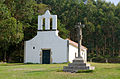
San Antonio do Corveiro

Punta Candieira

Petrified forest at the Miradoiro de Santo André de Teixido

Cruceiro de Teixido

Memorial plaque at the Cruceiro de Teixido

Cape Ortegal


traffic
The Serra can be accessed from Cedeira by the DP-2204 road and from Cariño by the DP-2205. Between the Miradoiro de Santo André and Santo André de Teixido , both are connected by a piece of narrow, paved mountain road. A number of narrow, partly unpaved mountain roads lead from this main connection into the mountain forest, to lighthouses and to lookout points.
Individual evidence
- ↑ María José Sánchez-Biezma, Regina Carballal: La sierra de A Capelada (A Coruña), un interesting enclave liquénico , Lazaroa 21: 7-11, 2000, ISSN 0210-9778 . Accessed October 2, 2014 (PDF)
- ↑ a b Display boards at the Miradoiro de Santo André de Teixido and at the Garita de Herbeira
- ↑ Tobias Büscher: Galicia and Jacobsweg. Dumont Reise-Taschenbuch, pp. 80 and 209. ISBN 978-3-7701-7397-6
- ↑ Tobias Büscher: Galicia and Jacobsweg. Dumont Reise-Taschenbuch, pp. 209-210. ISBN 978-3-7701-7397-6
Web links
Coordinates: 43 ° 43 '24 " N , 7 ° 56' 44" W.