
Shiba Park

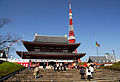
Shiba Park ( Japanese 芝 公園 , Shiba-kōen ) is a public park in the Minato district (Tokyo) , which encloses the Zōjō-ji .
Overview
Shiba Park, named after the former Tokyo district in which it is located, is one of the city's oldest public parks. It was opened to the public in 1873 along with Ueno , Asakusa, Fukagawa and Asukayama. Before the Second World War , the park also included the area of the Zōjō-ji, after the war the park was reduced to today's thin strip due to the separation of state and religion, which now encloses the temple and the grounds sold by the temple.
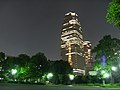
In the central part of the park is the former temple area, which has an old stock of trees. There rises a large prehistoric burial mound ( 芝 丸山 古墳 , Shiba Maruyama kofun ) of 106 m in length, on the hill of which there is a memorial stone for the important cartographer Inō Tadataka (1745-1818). In the west of this part of the park remains of a small pond are preserved, which had a Benzaiten shrine in the Edo period . The area in between was redesigned from 2001 to 2005, with the Shiba Golf Driving Range disappearing and the 31-story Tokyo Prince Hotel Park Tower being built. Near the Akabane Bridge there is a reference to the former Bakufu guest house, built in 1859 . B. 1860/61 the Eulenburg Mission , later Siebold and his son were also housed.
Separated from streets, but belonging to the park, the central part is enclosed in a ring
- in the east of a green strip along the Hibiya-dōri,
- in the south of an area with baseball and tennis courts and an indoor swimming pool,
- to the west of a forest that borders Tokyo Tower and where an "autumn foliage valley" ( も み じ 谷 , Momiji-tani ) with a waterfall was created in 1984 ,
- to the northwest by another strip of grass and finally
- to the north from the site of the former abbot's residence, which fell to the state soon after 1868. This is where the Minato District Library is located.
Characteristics
- Carrier: Tokyo Prefecture.
- Opening: October 19, 1873
- Area: 120,405.14 m²
- Tree population: 5574 trees, 22,556 bushy (1995)
- Predominant tree species: cherry, plum, camphor tree , ginkgo , matebashii
- Facilities: baseball and sports field, tennis courts, indoor swimming pool
- Access: Shiba kōen and Onarimon stations on the Mita Line (subway)
district
The park forms the core of the Shiba-kōen district of the same name , which is divided into four numbered quarters, chōme. The Tokyo Tower and Minato City Hall are located in the district . According to the 2005 census, the district had 1,019 inhabitants and a daily population of 21,969 on an area of 0.65 km².
literature
- Tōkyō-to (ed.): Shiba kōen , in: Toritsu kōen gaido, 1995.
- Map of the district ( kiriezu ) Shibaguchi minami , 1859.


Utagawa Kuniaki II


Web links
Individual evidence
- ^ Tokyo Prince Park Tower Hotel , skyscraperpage.com
- ↑ Shiba Park map , GMAP KK
- ^ Minato: Area and inhabitants by district
Coordinates: 35 ° 39 ′ 17 ″ N , 139 ° 44 ′ 53 ″ E