Inō Tadataka
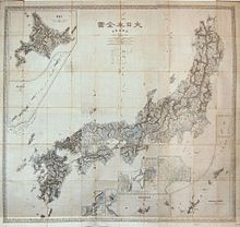
Inō Tadataka ( Japanese 伊 能 忠 敬 , or in respectful reading Inō Chūkei ; born February 11, 1745 in Kozeki, Kazusa Province (now Kozeki, Kujūkuri , Chiba Prefecture ), Japan ; † May 17, 1818 in Edo (now Tokyo )) a Japanese land surveyor and cartographer . He created the first map of Japan entirely based on measurements.
Early life
Inō was born as Kozeki Sanjirō ( 小 関 三 治郎 ) in the coastal village of Kozeki in the province of Kazusa (now part of Kujūkuri , Chiba Prefecture ) as the son of a fishing entrepreneur. At the age of 17 he was adopted by marriage by the Inō family in Sawara (now Katori, Chiba ) and called himself Tadataka from then on. As a merchant, he successfully ran the family's business in trading rice and making sake . At the age of 49 he withdrew, now three times widowed, and went to Edo , where he studied western astronomy , geography and mathematics as a late-calling student of the astronomer Takahashi Yoshitoki , who was almost 20 years his junior .
mission
In 1800 he received permission from the Tokugawa Shogunate to carry out surveys of the island of Hokkaidō at his own expense . At the age of 55, which was remarkably high for the time, his mission began, which fulfilled him for the remaining years of his life. Using modern western calculation methods, he finally measured the entire coastline and parts of the interior of Japan . He determined distances by counting steps, the distance of which he was able to keep constant with trained accuracy regardless of the terrain. His records report a total of 3,736 working days on which he covered 34,913 kilometers - mostly on foot. He created a comprehensive work of detailed maps on a scale of 1: 36,000 and 1: 216,000, mainly of the islands of Kyūshū in the southwest and Hokkaidō in the northeast of Japan.
Inō's death in 1818 was kept secret so that his employees could complete his life's work in his name. In 1821 the map series appeared under the title Dai-Nihon Enkai Yochi Zenzu ( 大 日本 沿海 輿 地 全 図 , German: " Overall map of the coastal areas of Greater Japan"). It covers the entire archipelago on eight sheets on a scale of 1: 216,000, plus selected coastal strips on 214 sheets on a scale of 1: 36,000 as well as a further overall map on three sheets on a scale of 1: 431,000. With 1.6 m² each, the individual card sheets are the size of a rice straw mat ( tatami ).
meaning
Inō's maps have an amazing accuracy of up to 1/1000 of a degree. They were used well beyond the Meiji period and made him one of the architects of modern Japan. His hometown of Sawara dedicated a museum to him, which was named a National Historic Site in 1996. In 1995, on the occasion of his 250th birthday, an 80 yen stamp was issued with his portrait and a section of a map of Edo Bay (now Tokyo).
Inō was buried at his own request next to the grave of his teacher Takahashi Yoshitoki in the cemetery of the Genkuji Temple in Asakusa . His tombstone bears the inscription: Tōga Inō Sensei no Haka ( 東河 伊 能 先生 之 墓 , "Grave of the scholar Tōga Inō") In addition to his maps, he published scientific articles on surveying technology and mathematics.
The original maps were destroyed in a fire in the Imperial Palace in Tokyo on May 5, 1873 , and the most important copies were lost in the Great Kanto earthquake on September 1, 1923 . A nearly complete collection of copies of the large-scale map, 206 of 214 sheets, was discovered in 2001 in the US Library of Congress . This means that a total of 208 sheets are preserved today.
Literary reception
In the graphic novel The Cartographer , Jiro Taniguchi pays tribute to Ino Tadataka and his wanderings through Edo in the second half of the 18th century in 15 chapters .
See also
literature
- Ryokichi Otani: Tadataka Ino: The Japanese Land-Surveyor , Simon Publications, 2001, ISBN 978-1-931541-22-0
Web links
- Official website of the Inō Tadataka Museum (Japanese)
Individual evidence
- ↑ Japanese yūsokuyomi ( 有 職 読 み ). The Japanese name reading was replaced by a Sino-Japanese on reading .
- ↑ The grave of Inō Tadataka ( Memento of the original from August 15, 2010 in the Internet Archive ) Info: The archive link was inserted automatically and has not yet been checked. Please check the original and archive link according to the instructions and then remove this notice. . Inō had written Chinese poems under the name Tōga (East River) during his lifetime .
- ↑ The free library: Copy of Ino Tadataka's map of Japan found in US
- ↑ Deutschlandfunk Kultur [1] Deutschlandfunk Kultur: book review / archive | Posted on December 30, 2013.
| personal data | |
|---|---|
| SURNAME | Inō Tadataka |
| ALTERNATIVE NAMES | 伊 能 忠 敬 (Japanese); Inō Chūkei (on reading) |
| BRIEF DESCRIPTION | Japanese surveyor and cartographer (1745-1818) |
| DATE OF BIRTH | February 11, 1745 |
| PLACE OF BIRTH | Kozeki, Kazusa Province (now Kozeki, Kujūkuri , Chiba Prefecture ), Japan |
| DATE OF DEATH | May 17, 1818 |
| Place of death | Edo (now Tokyo ), Japan |


