Sierra Carapé
Coordinates: 34 ° 20 ′ 0 ″ S , 54 ° 39 ′ 0 ″ W.
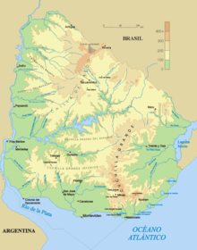
The Sierra Carapé (also known as Sierra de Carapé ) is a smaller range of hills in southern Uruguay . It runs from the Maldonado department eastwards into the Rocha department in the east. The range of hills represents the border to the Lavalleja Department in the north. The Sierra Carapé connects directly to the Cuchilla Grande in the north .
In this chain of hills, in which the source of the Río Santa Lucía lies, is the highest point in Uruguay, the 514 meter high Cerro Catedral .
There are marble deposits in the Sierra de Carapé .
gallery
See also
Web links
- Cerro Catedral ( Memento of May 24, 2011 in the Internet Archive ) on the site of the city of Maldonado
- Cerro Catedral on Peakbagger.com (English)
Individual evidence
- ^ Prof. Ulises Rubens Grub : Atlas geografico de la República Oriental del Uruguay, Montevideo 1980, p. 35


