Río Santa Lucía
Data
location
South America , Uruguay
River system
Río de la Plata
Drain over
Río de la Plata → Atlantic
source
at Cerro Pelado in the Sierra Carapé
Source height
250 m
muzzle
in the Río de la Plata coordinates: 34 ° 47 ′ 7 ″ S , 56 ° 21 ′ 31 ″ W 34 ° 47 ′ 7 ″ S , 56 ° 21 ′ 31 ″ W. -34.785277777778 -56.358611111111 -34.785277777778 -56.358611111111
length
230 km
Catchment area
13,448 km²
Left tributaries
Arroyo Tortora , Arroyo del Perdido , ( Arroyo Campanero Grande or Arroyo San Francisco ), Arroyo Verdún , de las Conchas, de las Burras, del Sauce, Zabaleta, de las Nutrias, de los Gransos, del Tigre, de Bolívar, Arroyo La Rambla , Arroyo Vejigas , Arroyo Vejigas Viejo , Arroyo Pilatos , Lázaro, NN, La Lana, Arroyo del Tala , del Medio, Icasuriaga, Velázquez, de las Pajas, Vidal, Arroyo Canelón Grande , de Montaño, Arroyo del Juncal , Arroyo de la Lista , Arroyo Barrancas Coloradas , Arroyo Durán , Arroyo de las Brujas Grande , Arroyo Colorado , Pajas Blancas, Arroyo del Peral , de las Conchas
Right tributaries
NN, NN, NN, NN, Arroyo de la Calera , Arroyo del Soldado , Arroyo de los Chanchos , del Camino, Arroyo Casupá , Arroyo Latorre , La Rambla, Arroyo Viejo , Arroyo Chamizo Grande , Arroyo Santa Ana , Pantanosa, NN, NN , (Arroyo Pelado or Arroyo de Mendoza) , Río Santa Lucía Chico , Guerrero, Arroyo de la Virgen , Santa Lucía, de Echevarría, del Medio, Tropa Vieja, NN, Arroyito Ojo de Agua , Arroyo Toscas Chico ?, Arroyo de las Tortugas , Arroyo de las Toscas
The Río Santa Lucía is a river in Uruguay .
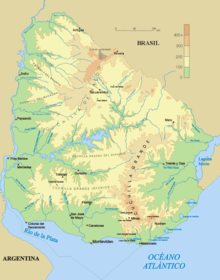
geography River course The 230 kilometer long river has its source at an altitude of 250 meters above sea level on Cerro Pelado in the Sierra Carapé . From its source there in the Lavalleja department near the city of Minas, it flows from east to west, forming the border between the Florida and Canelones departments . Then its course changes in a southerly direction, where it now separates the departments Canelones and San José from each other. It flows past the city of Santa Lucía , from the city of Aguas Corrientes the river is navigable. In the last section of the river up to its confluence with the Río de la Plata there are several river islands. The Isla del Tigre lies in front of the tip of the estuary itself, which is located near the city of Santiago Vázquez .
Tributaries u. a .: Arroyito Piedras
Catchment area The Río Santa Lucía, which is used for drinking water supply, is fed by the Río Santa Lucía Chico and the Río San José, along with many other tributaries . The size of its catchment area is 13,448 km².
Map showing the course of the river
Web links Individual evidence
↑ So far, the infobox contains the tributaries from the source to Paso Roldán
↑ So far, the infobox contains the tributaries from the source to Paso Roldán
↑ DIRECTRICES DEPARTAMENTALES DE ORDENAMIENTO TERRITORIAL Y DESARROLLO SOSTENIBLE DE SAN JOSE (PDF; 3.4 MB)
<img src="https://de.wikipedia.org//de.wikipedia.org/wiki/Special:CentralAutoLogin/start?type=1x1" alt="" title="" width="1" height="1" style="border: none; position: absolute;">

