
Silver pond
| Silver pond | |||||||||
|---|---|---|---|---|---|---|---|---|---|
 |
|||||||||
|
|||||||||
|
|||||||||
| Coordinates | 51 ° 43 '27 " N , 10 ° 34' 53" E | ||||||||
| Data on the structure | |||||||||
| Lock type: | dam | ||||||||
| Construction time: | 1755 | ||||||||
| Height of the barrier structure : | 8 m | ||||||||
| Crown length: | 90 m | ||||||||
| Operator: | Harz National Park | ||||||||
| Data on the reservoir | |||||||||
| Water surface | approx. 1.4 ha | ||||||||
| Reservoir length | 300 m | ||||||||
| Reservoir width | 80 m | ||||||||
| Total storage space : | 22nd 000 m³ | ||||||||

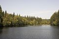
The silver pond is an artificial pond on the upper reaches of the Brunnenbach between Braunlage and Sankt Andreasberg in the Harz Mountains in Lower Saxony . Due to the history of its origins, it is part of the Upper Harz water shelf and is part of the Rammelsberg World Heritage Site , the old town of Goslar and the Upper Harz Water Management .
description
The water surface is about 300 meters long and its dam is about 8 meters high. The material for building the dam comes from the quarry on the west bank in the immediate vicinity of the dam. The pond is now in the middle of the Harz National Park, which is also its operator here. On the east bank a path leads along the water in parts, but otherwise the paths were kept away from the water in order to create a quiet zone for flora and fauna.
history
The silver pond was created in 1755, and two dam elevations were implemented during the construction period. Its design corresponds to the new construction of the Upper Harz ponds with a core seal made of turf. The slopes were initially too steep and had to be repaired several times; Obviously, the dam elevations were not linked to a widening of the dam's contact area. The silver pond was supposed to supply mines located southwest of it with water power. It was a matter of hoping mining, which was heavily supported by the mining authorities and had to be finally stopped around 1780 due to a lack of profitability. The silver pond was subsequently used by the Braunlager Blaufarbenwerk (“forest mill” at the same location today), which drew its energy from the reservoir. Originally it was called "Andreasberger Teich" or "Brunnenbacher Teich". The current name was chosen more recently to highlight this place as a tourist destination.
When walking the beaten path on the east bank, the trained eye will notice that this path is a former hillside ditch parallel to the contour lines. It is very likely that this was created in order to be able to largely bypass flooding by the pond.
Surroundings
The Sankt Andreasberger Fußstieg leads over the top of the dam and connects Braunlage with Sankt Andreasberg by the shortest route.
The dam broke on December 4, 1760
At the beginning of December 1760 there were heavy rains and floods, obviously in connection with the snowmelt. In the night of December 3rd to 4th, the dam of the pond was flooded in the area of the outflow, which was additionally impaired by ice floes, and then broke to a length of 30 meters. The flood of water tore away the Brunnenbachsmühle located about 5 km below; all 4 residents were killed. The cause of this accident, which took place only 5 years after its completion, was presumably a flood relief system of too small dimensions , combined with an impairment of this overflow by ice floes. It was not rebuilt until 1763, after which the silver pond was also called the "new pond" until around 1900.
Picture gallery

The Andreasberger Stieg on the top of the dam of the silver pond

The overflow of the silver pond into the Brunnenbach from the lake

... and the stream side
View from the dam towards the reservoir root in the north


See also
Web links
Individual evidence
- ↑ a b Martin Schmidt : Particular cases of damage to the Upper Harz pond dams. In: Leichtweiß Institute for Hydraulic Engineering at the Technical University of Braunschweig. Messages. Issue 103, 1989, ISSN 0343-1223 , pp. 383-421.
- ↑ a b c d e Wilfried Ließmann : The silver pond near Braunlage and the mining in the Odertaler Revier . In: General Harz Mountain Calendar for 2001 . ISSN 1867-5395 , p. 126-135 .