Palenica ski area

The Palenica ski area is located on the northern slopes of the Palenica in the Polish mountain range Little Pienines in the municipality of Szczawnica in the powiat Nowotarski in the Lesser Poland Voivodeship . It is located outside the Pieniny National Park , near the DW969 voivodeship road. The ski area is operated by the company Polskie Koleje Linowe SA. The ski area is a member of the TatrySki association , which issues a joint ski pass.
location
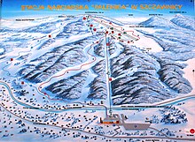
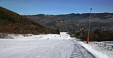
The ski area is located at an altitude of 456 m above sea level to 720 m above sea level. The difference in altitude between the slopes is approx. 264 m. There are two red (difficult) and two blue slopes. The total length of the slopes is approx. 4 km. The longest slope is around 1.8 km long.
history
The ski area was created in the 1980s. The ski lift was built in 1991 and expanded in 2005.
description
Ski lifts
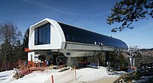
There is a chair lift and four button lifts in the ski area. A total of up to 5480 people can be transported per hour.
Butorowy Wierch ski lift
The ski lift leads from Szczawnica to just below the Palenica ridge. Its length is approx. 1000 m.
| Surname | Art | Manufacturer | Broad people | Length (m) | Time (min) | Height difference (m) | People per hour | Upper station | Lower station | Vmax (m / s) |
||
|---|---|---|---|---|---|---|---|---|---|---|---|---|
| place | Height (m above sea level) | place | Height (m above sea level) | |||||||||
| Palenica ski lift | Chairlift | Doppelmayr / Garaventa Group | 4th | 783 | 2 | 2200 | Under the summit | 720 | Lower station | 456 | ||
| 2 | Button lift | 1 | 310 | 760 | ||||||||
| 3 | Button lift | 1 | 333 | 760 | ||||||||
| 4th | Button lift | 1 | 258 | 760 | ||||||||
| 5 | Button lift | 1 | 100 | 1000 | ||||||||
Ski slopes
Four ski slopes lead from Magura Palenica into the valley.
| Surname | difficulty | begin | target | Length (m) | Height difference (m) | Tilt (%) | light | Artificial snow | FIS | Remarks | |||
|---|---|---|---|---|---|---|---|---|---|---|---|---|---|
| Surname | Height (m above sea level) | Surname | Height (m above sea level) | number | to | ||||||||
| Palenica | red | Upper station | 719 | Lower station | 456 | 1000 | 263 | 26th | No | Yes | |||
| Szafranówka I | blue | Upper station | 723 | Middle station | 400 | 75 | 19th | Yes | Yes | ||||
| Szafranówka II | red | Upper station | 735 | Middle station | 500 | 100 | 20th | No | Yes | ||||
| Palenica II | blue | Upper station | 723 | Lower station | 453 | 1800 | 270 | 15th | Yes | Yes | |||
| Halfpipe | Upper station | 710 | 150 | 20th | 13 | No | Yes | ||||||
Infrastructure
The ski area is right in the center of Szczawnica and can be reached by car. There are parking spaces at the lower station and several restaurants at the lower and upper station. There is a ski school and a snow park in the ski area. There is also a ski rental and a ski workshop.
See also
Web links
Coordinates: 49 ° 25 ′ 26 ″ N , 20 ° 28 ′ 47 ″ E


