Skippers Canyon
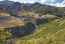
Skippers Canyon is a approximately 22 km long canyon north of Queenstown in the south of the South Island of New Zealand . The canyon branches off the road from Queenstown to Coronet Peak today . The canyon was dug by the Shotover River and was one of the richest gold deposits in New Zealand. The river got its name from William Gilbert Rees, who with his wife Francis and brother-in-law Nicholas von Tunzelmann was the first European settler in the area of what is now Queenstown.
Start of the gold rush
In November 1862, Thomas Arthur and Harry Redfern found about 4 ounces (about 113 g) of gold in the area of today's Arthurs Point within 3 hours . Since Arthur and Redfern made no secret of their discovery, a large number of other gold diggers soon tried their luck in the valley. This was the beginning of a gold rush mining site in Otago . Soon after the start of the gold rush, prospectors named the Shootover River the "richest river in the world". However, there is no evidence of this as there are no official records of the amount of gold actually found.
Charlestown
Charlestown was a small settlement in Skippers Canyon. After the first gold finds, the prospectors followed the gorge over Arthur's Point upstream. They had to find their way over impassable hills, as the river itself was deep and fast and runs over large parts in steep-walled gorges. The miners nevertheless advanced up the river and descended where possible to the river. Soon there was an important gold find at what was then known as "Māori Point". The two Māori miners Dan Ellison (Raniera Erihana) and Hakaria Maeroa reached a hidden gorge in Skippers Canyon. Since the opposite bank looked promising, they tried to cross the river. One of their dogs tried to follow them and was washed away. Ellison came to his aid and was able to save him. On the bank he saw some gold particles in crevices and began to examine the sand below. The two of them collected around 8.5 kg of gold at this point before nightfall.
This find was the hour of birth of Charlestown, which emerged on the flat land at Māori Point. Hotels, butchers, bakers, a post office and a bank were built. There was a police station and a local magistrate (justice of the peace) appointed to resolve claims disputes. Charlestown experienced a brief boom with up to 1000 residents. In 1864, the easily accessible part of the gold was mined and the population fell to 400. Today there is little to remind us of Charlestown: stones from an overturned chimney, a small memorial plaque and an information board.
Skippers Point
Canyon and Skippers Point were named after 'Skipper' Malcolm Duncan, who found gold at what is now Skippers Point in 1862. Born in Northern Ireland, Duncan worked on American ships for a number of years and was nicknamed 'Skipper'. Duncan was drawn to the gold rush and found gold on a tributary of the Shootover River, now Skippers Creek. This area soon became known as "Skippers Point" or "Skippers".
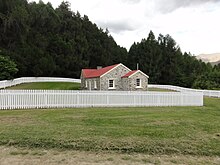
In addition to Duncan, several other gold miners staked claims in the Skippers Point area, which they exploited until the early 1900s. The remains of their water channels, dams, flooding systems and spoil heaps are still visible today. Like Charlestown, Skippers Point initially had up to 1,000 residents, but by 1864 their number had stabilized at around 200. At one point there were six hotels in the resort. Today only the residential building of the farm Mount Aurum Station and the stone school building and the cemetery are visible. "
Skippers Road
Skippers Road , which runs through the canyon, is one of New Zealand's lesser known tourist roads. It is one of two roads in New Zealand that are not allowed to be driven by rental cars and are therefore not covered by insurance. The road is open to the public, but the narrow road for the most part only offers space for one vehicle and is bordered over long stretches by steep cliffs on one side and a slope that is several hundred meters deep on the other.
At the beginning of the gold rush, there was no path in the canyon. The miners pulling their horses through the canyon created paths. Although uneven and steep, they provided access to Deep Creek, Māori Point, and Skippers in 1863. However, these paths were unsafe and sometimes the packhorses and their cargo were lost.
The need for a safe road to skippers, on which one could also transport heavy equipment for gold mining, grew. Skippers Road was measured around 1883. The road was built by four contractors in several stages over the next 7 years. Many parts of the road are in a similar condition today as they were in 1890.
However, at that time the road was bordered on the valley side by low dry stone walls. After the horse-drawn carts had been replaced by cars, the walls were removed with the exception of a few remains and used as a road surface.
It has been said that more money was spent on the road than all the gold mined could bring in. However, this comment is more figurative and expresses the enormous cost and difficulty of building and maintaining it. The volcanic stone is so soft here that it is quickly ground to dust by traffic, which turns into a greasy mud when wet. That is why motor vehicles were banned on the road at the beginning of the 1900s.
By that time, the gold rush was largely over, so some residents of the Queenstown district saw potential for possible use of the street as a tourist attraction. Soon after completion, day tours in horse-drawn carriages with 10 seats were offered from Queenstown, which start at 8 a.m. and reach Mt. Aurum Station at Skippers Point after a five-hour drive. After changing horses, they returned to Queenstown at 6 p.m. The 19 shillings fare included morning tea and lunch.
There were petitions to allow cars in the canyon and others who wanted to prevent this. The dispute was finally decided by the court: Cars were allowed to enter Canyon in the future, but permission had to be obtained and the times of use were determined. Violations were fined $ 10.
Skippers Bridge
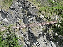
The first bridge built over the river at Skippers Point in 1866 was a suspension bridge that was only 6 meters above the water level and was therefore easily damaged during floods. The next bridge was built in 1871 in the same place. The transition remained difficult, as steep access roads had to be negotiated on both of the canyons. When the road to Skippers Point was completed, plans were made for a new bridge about 100 m above the river. Work on this began in 1898 and lasted two years. In March 1901 the bridge was officially inaugurated by the Mining Minister and replaced the old bridge. The stone driveways of the old bridge can still be seen from the street.
Power generation
Bullendal , a small gold digging settlement about a 4 hour walk from the end of Skippers Road up Skippers Canyon, was the first place in New Zealand where hydropower was used to generate electricity on an industrial scale.
Todays use
Mining ceased and all settlements abandoned. Today farmers still live in two places in the valley.
Today the valley and Skippers Road are primarily a tourist attraction. It was registered with the New Zealand Historic Places Trust on December 15, 2006 under number 7684. Two companies offer trips into the canyon in four-wheel drive minibuses; the number of visitors was limited to protect the valley.
Commercial bungee jumps used to be offered from a steel bridge over the Shootover River in the central part of the canyon . There are rafting tours down the Shootover River and speed boating in the lower part of the canyon. The valley is also used for outdoor camps for New Zealand school classes.
Individual evidence
- ^ A b Vincent Pyke, Early Gold Discoveries in Otago, 1887, mentioned in: Goldfields of Otago, John Hall-Jones, Craig Printing, 2005
- ^ A b Danny Knutson, The Road to Skippers, Reed Books, 1974 (Reprint 1980, new edition 1995)
- ↑ a b c d e f g h Golden Canyon, FW Craddock, Pegasus Press, 1973
- ↑ a b c d e f g h i j k l m Goldfields of Otago, John Hall-Jones, Craig Printing, 2005
- ↑ a b Terri Macnicol, Echoes of Skippers Canyon, Reed Books, 1967
- ↑ Illustrated History of Central Otago & the Queenstown Lakes District - Reed Publishing 2005 - Gerald Cunningham
- ^ Historic Places Trust
Web links
Coordinates: 44 ° 52 ′ 43.9 ″ S , 168 ° 37 ′ 35.4 ″ E


