Spinalonga Peninsula
| Spinalonga Peninsula / Kolokytha Peninsula (Χερσόνησος Σπιναλόγκας / Χερσόνησος Κολοκύθας) | ||
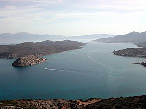
 Spinalonga peninsula (left) with Kalydon |
||
| Geographical location | ||
|
|
||
| Coordinates | 35 ° 16 '18 " N , 25 ° 44' 48" E | |
| Waters 1 | Gulf of Mirabello | |
| Waters 2 | Aegean Sea | |
| length | 5.2 km | |
| width | 2.2 km | |
The Spinalonga Peninsula ( Greek Χερσόνησος Σπιναλόγκας ( f. Sg. )) Also Kolokytha Peninsula (Χερσόνησος Κολοκύθα ( f. Sg. )) Is located in the Gulf of Mirambello in the northeast of the Greek island of Crete. In the southwest there is a connection with Crete via the isthmus of Poros (Ισθμός Πόρου), which is only a few meters wide, and Poros of Elounda (Πόρος της Ελούντας) near Elounda . The approximately 5.2 km long and maximum 2.2 km wide Spinalonga Peninsula separates the Gulf of Elounda (κόλπου της Ελούντας) from the Gulf of Mirabello. The coastline is divided by larger bays. The island of Spinalonga is offshore in the north and Kolokytha in the southeast .
In Minoan times, the city of Olous was located on the isthmus, which was around 200 m wide . During the French command of Mirabello shortly before the independence of Crete , a canal was built through the isthmus from 1897 to 1898.
Individual evidence
- ↑ Μαρία Αρακαδάκη: Το φρούριο της Σπιναλόγκας (1571-1715) . Συμβολή στη μελέτη των επάκτιων και νησιωτικών οχυρών της Βενετικής Δημοκρατίας. Thessaloniki 1996, p. 428 , here p. 192f (Greek, online dissertation Aristotle University of Thessaloniki ).
