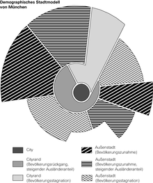
City model
A city model or city structure model is the idealized and simplified representation of the spatial, social, economic and cultural structure of a city in a specific region for a specific historical time frame. Well-known historical city models include the Roman city , medieval city , baroque city , socialist city .
For the description of the socio-structural organization of cities in Europe and North America, the models of the Chicago School are particularly important. The model of the concentric rings by Burgess , the sector model by Hoyt and the multicore model by Harris and Ullman each describe a certain conception of the spatial segregation of population groups (see segregation ), which can either only be statistically proven for the urban space or also appears morphologically .
Adapted regional-specific models are known for the Oriental City and the Latin American City .
There are numerous other geographic city models. What they have in common is the attempt to depict the formation and development processes of urban settlements in a generally valid way.
These graphic models - which are not missing in any textbook - often lead to direct conclusions about reality, which is not possible due to the high level of abstraction and mostly missing information on model restrictions. In reality, influenced primarily by the economic situation of a city, but also by the economic or ethnic status of population groups, all three models overlap.
Overview of the three best-known city models: (Figure on the right)
| author | year | idea |
|---|---|---|
| EW Burgess | 1925/1929 | Zone model |
| H. Hoyt | 1939 | Sector model |
| CD Harris and EL Ullman | 1945 | Multi-core model |
See also
literature
- Heinz Heineberg : urban geography . 3. Edition. Schöningh, Paderborn 2006, ISBN 3-8252-2166-0 .

