
City lake (Sulingen)
| City lake | ||
|---|---|---|

|
||
| City lake from the east bank, looking west, October 2013 | ||
| Geographical location | Sulingen , Diepholz district , Lower Saxony | |
| Islands | 2 | |
| Places on the shore | Sulingen | |
| Data | ||
| Coordinates | 52 ° 40 ′ 31 ″ N , 8 ° 47 ′ 44 ″ E | |
|
||
| surface | 6.4 ha | |
| Maximum depth | 4.8 m | |
| Middle deep | 2.5 m | |
|
particularities |
||

The Stadtsee is a quarry pond in the town of Sulingen in the Diepholz district , Lower Saxony .
description
It was created in 1990 when a bypass was being built . The lake was designed as a landscape and recreational lake and, together with the surrounding area, is used for local recreation . The recreation area is around 20 hectares in total.
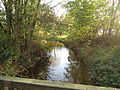
The bank areas of the lake are mostly green, partly grass, partly shrubs. There are two small islands in the lake, which are connected to the shore by footbridges. The larger of the two islands serves as a bathing island. There is no lifeguard. There are also no sanitary facilities. The Sule flows past the east bank of the lake a few meters away.
The local recreation area is accessible by bike and hiking trails. A path leads around the lake. To the east of the lake there is a motorhome parking space with a supply and disposal station.
The Museum am Stadtsee is located north of the city lake .
Picture gallery

City lake with sunbathing lawn, June 2014

Museum at the city lake
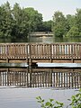
Jetties in the lake

Sule on the northeast side of the city lake, looking north, November 2013
Pillar with a view to the south and the city lake on the right in the background


See also
Web links
- Stadtsee , bathing water atlas Lower Saxony