
Lutry Stone Row
| Lutry Stone Row Alignement de Lutry | |||
|---|---|---|---|
 Lutry Stone Row |
|||
|
|||
| Coordinates | 46 ° 30 '12 " N , 6 ° 41' 5.9" E | ||
| place | Lutry , Vaud , Switzerland | ||
| Emergence | Neolithic | ||
| Dimensions | 23 menhirs | ||
| height | 380 m | ||

The Lutry Stone Row is a megalithic site in Lutry , Switzerland .
location
The row of stones is located on the southern edge of a parking lot northwest of the old town of Lutry on the right bank of the Lutrive .
history
During excavation work for a parking garage in 1975, 23 menhirs (" menhirs ") from the Neolithic era were discovered in the alluvial soil of the Lutrive River , the largest of which weigh around 13 tons. The menhir complex was erected in its original formation in 1986 and reconstructed a few dozen meters south of the original location.
Megalithic plant
The 23 menhirs are arranged in decreasing size on both sides of the largest, central and originally four meter high block. The stones are connected to each other almost without a gap. The row of stones consists of two segments. The first segment comprises 12 menhirs, which are aligned on an east-west line and are up to three meters high. The second segment represents a curve to the south, the stones of which are no higher than 80 cm.
A menhir has engravings in the shape of a human face. The original is on display in a showcase in the passage (Passage du Simplon) to the Reformed Church.

Segment of large menhirs
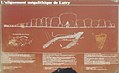
Information board at the parking lot

Menhir with human-shaped outlines

Information board in the Passage du Simplon


Chronological order
So far, the experts had assumed that erect stones come from the Bronze Age. The row of stones on Cut Hill , discovered in 2004, was the first to be dated using radiocarbon dating of the treasure trove. It dates from 3,500 BC. BC and thus shows that the oldest north-western European stone rows come from the Neolithic , even if there were still constellations in the Iron Age.