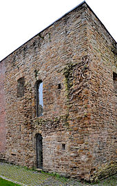
Stenshofturm
The Stenshofturm (also Romanesque House ) is a from sandstone erected medieval tower house today Külshammerweg 32 in Essen district Rüttenscheid . It is located on the grounds of the Grugapark .
Naming
The name of the Stenshofturm is derived from a farm in which the tower was integrated centuries ago. The farm, in turn, was named Stenshof after the Stens family who owned it.
The original word Sten walked over Stennes and Stenhus in stone house .
history
The residential tower, originally with three floors, dates from the first half of the 12th century and is said to have been connected to the Rüttenscheid farm in the vicinity. The latter is mentioned as early as 1215/41 as the seat of Werdener Ministeriales. For this reason, it is assumed that the Stenshofturm is also a former staff seat . The Stenshof itself is first mentioned in documents in 1386 and 1398. In 1400 Hinrikus Vrowenloff was enfeoffed with the servant estate To deme Steynhus .
In 1904 Heinrich Stens sold the Stenshof to the city of Essen. Subsequently, the city nursery was relocated there.
In 1962/63 the old Stenshofturm was secured. The entry in the list of architectural monuments of the city of Essen took place on February 14, 1985.
In 2009, the Association of Sample Gardens in Grugapark e. V. with the revitalization of the plant. Since 2010 the Stenshofturm has been an exhibition and seminar location and is open to the general public.
See also
literature
- Hugo Rieth: Silberkuhlsturm and Stenshofturm (Romanesque house) in Essen. In: Rheinische Heimatpflege . Vol. 2, No. 4, 1965, pp. 332-346.
- Werner B. Kreutzberger, Leo Schaefer: The Stenshofturm in Essen. In: Yearbook of the Rhenish Preservation of Monuments. Volume 26, 1966, pp. 75-108.
Web links
- Entry in the list of monuments of the city of Essen from February 14, 1985 (PDF; 443 kB)
- Romanesque house at www.grugapark.de
- Stenshofturm at www.eabg.essen.de
- Romanesque house at www.rheinruhronline.de
Individual evidence
- ↑ Flyer Grugapark zum Stenshofturm (PDF; 735 kB) (including old photos on the history of the building), accessed on August 9, 2013.
Coordinates: 51 ° 25 ′ 45.3 " N , 6 ° 58 ′ 59.3" E
